Displaying items by tag: dana soehn
Helene: Colquitt Foundation gives $750,000 for ongoing recovery in Smokies
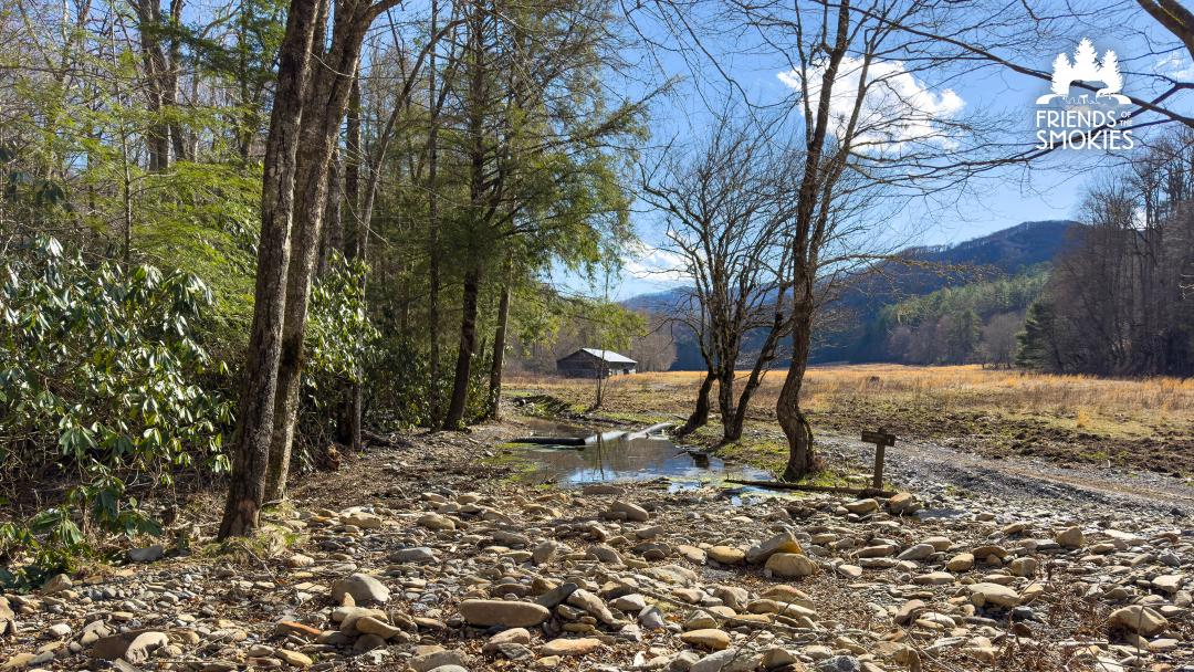 Damage to Cataloochee Road with the Caldwell Barn in the background in Great Smoky Mountains National Park. Repairs following Tropical Storm Helene continue and will be supported by a grant from the Colquitt Foundation. Friends of the Smokies
$750K donation to Friends of the Smokies part of a larger $2 million commitment to assist Hurricane Helene recovery
Jim Matheny is Friends of the Smokies communications director.
KODAK — Reflecting a longtime devotion to Great Smoky Mountains National Park, The Colquitt Foundation has given $750,000 to the nonprofit Friends of the Smokies to save historic structures and help the national park’s Cataloochee Valley recover from damage caused by Hurricane Helene.
“Hurricane Helene left its mark on Cataloochee Valley. Cataloochee Ranch was founded in that valley, and we feel a responsibility to help. We are honored to partner with Friends of the Smokies to contribute towards its revival and restoration,” David Colquitt said.
The Colquitt Foundation made the gift on behalf of The Swag as well as Cataloochee Ranch, two historic mountain retreats operated by the Colquitts on the boundary of Great Smoky Mountains National Park in Haywood County, North Carolina.
“Cataloochee Valley is a jewel for our entire region. Its cultural, historical, environmental and recreational value is something that cannot be replaced. On behalf of our 150+ Haywood County team members, we are honored to make this contribution,” Annie Colquitt said.
The $750,000 gift to Friends of the Smokies will fund restoration of historic structures damaged by Hurricane Helene in September 2024, including cabins and barns from Cataloochee to Cosby. Through the Forever Places program, these critically needed funds will provide materials, supplies and support for a skilled staff of historic preservation experts to make the needed repairs.
- hurricane helene
- hurricane helene cataloochee
- hurricane helene smokies
- hurricane economic loss
- hurricane helene western north carolina
- colquitt foundation
- the swag
- david colquitt
- caldwell barn cataloochee
- helene repairs in smokies
- dana soehn
- friends of great smoky mountains national park
- friends of the smokies
- beech grove school
- cataloochee ranch
Helene hits the mountains: 600 missing; major roads and railroad links cut; massive recovery underway; havoc in So. Appalachians

KNOXVILLE — The remnants of Hurricane Helene dumped up to 20 inches of rain on the Appalachian mountains along Tennessee’s border with North Carolina, causing historic floods that forced thousands of people to evacuate their homes and shattering records that had stood for more than a century.
The Buncombe County Sheriff’s Office said at least 30 people had died in that county alone; those numbers are expected to climb. CNN reports death toll in NC has climbed to 56; SC 33; GA 25; FL 15; TN 9; VA 2.
MSN reported 600 people are still missing. 85 are missing in East Tennessee since Helene arrived.

For lack of power and water, about 400 offenders had to be moved from the Correctional Center for Women in Swannanoa and the Black Mountain Substance Abuse Treatment Center for Women to other accessible correctional facilities in North Carolina.
In some counties fewer than 10% of cell towers are fully functional.
FEMA Administrator Deanne Criswell is in North Carolina to survey damage alongside Governor Roy Cooper. The Administrator also met with response officials about the ongoing efforts to help survivors in the hard-hit communities. Administrator Criswell will remain on the ground in North Carolina until the situation has stabilized, as directed by President Joseph R. Biden. 3,500 federal personnel helping with search and recovery across Hurricane Helene disaster areas.
The hits keep coming on both sides of the mountains
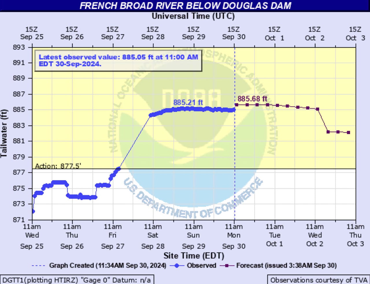
At 9:24 p.m. Sunday, the regional office of the National Weather Service in Morristown issued a flood warning for Sevier and Knox counties because of upstream water releases at Douglas Dam to regulate the massive surge of water into the Tennessee Valley Authority reservoir system over the past week. This Flood Warning extends until 7:30 p.m. Oct. 1.
 Touch the graph to view its most recent update.
“An upstream floodgate release is expected to continue to cause flooding and evacuations will continue as deemed necessary by local emergency personnel in low-lying communities and neighborhoods along the French Broad River,” according to the urgent bulletin from the NWS. “If you live in a low-lying area near the river and feel your residence may be threatened, please self-evacuate. Continue to follow guidance from local law enforcement, fire/rescue agencies, and emergency management staff.”
 The power of water is on raw display in the Nolichucky River Gorge following devastating floods unleashed by Tropical Storm Helene in northeast Tennessee and Western North Carolina. Jon Mitchell
In a somber video press briefing Sunday afternoon attended by tired-sounding officials from various Buncombe County governments and a Duke Energy representative, Buncombe County Sheriff Quinten Miller shared a “devastating” update: The death toll throughout Buncombe County increased to at least 30. He said search and rescue continues, but recovery footing looms as families continue “grieving tremendous losses.” Little other information was immediately available, such as specific areas where victims may have been clustered.
Thousands of people still need help. A lack of water, telecommunications issues and limited access to affected areas are main problems for the county at this point, officials agreed.
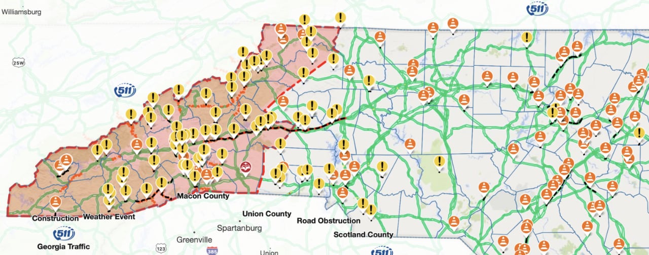 All roads in Western North Carolina (area shaded pink) still must be regarded CLOSED as per North Carolina Department of Transportation.Touch the map to update it to its current status.
People wanting to donate goods or money to local relief efforts can email This email address is being protected from spambots. You need JavaScript enabled to view it..
The call was sporadically interrupted by apparent cellular issues; Verizon and other telecommunications providers are under increasing fire, with few reasons offered for the near-collapse of cellular service in the region.
The hardest hit communities in East Tennessee appeared to be in Cocke and Carter counties along the Pigeon, French Broad and Nolichucky rivers, according to the National Weather Service.
Nolichucky River floodwaters felled two bridges on Interstate 26 between northeast Tennessee and North Carolina near Erwin.
 Western North Carolina is now effectively cut off from eastbound interstate travel. Tennessee Highway Patrol
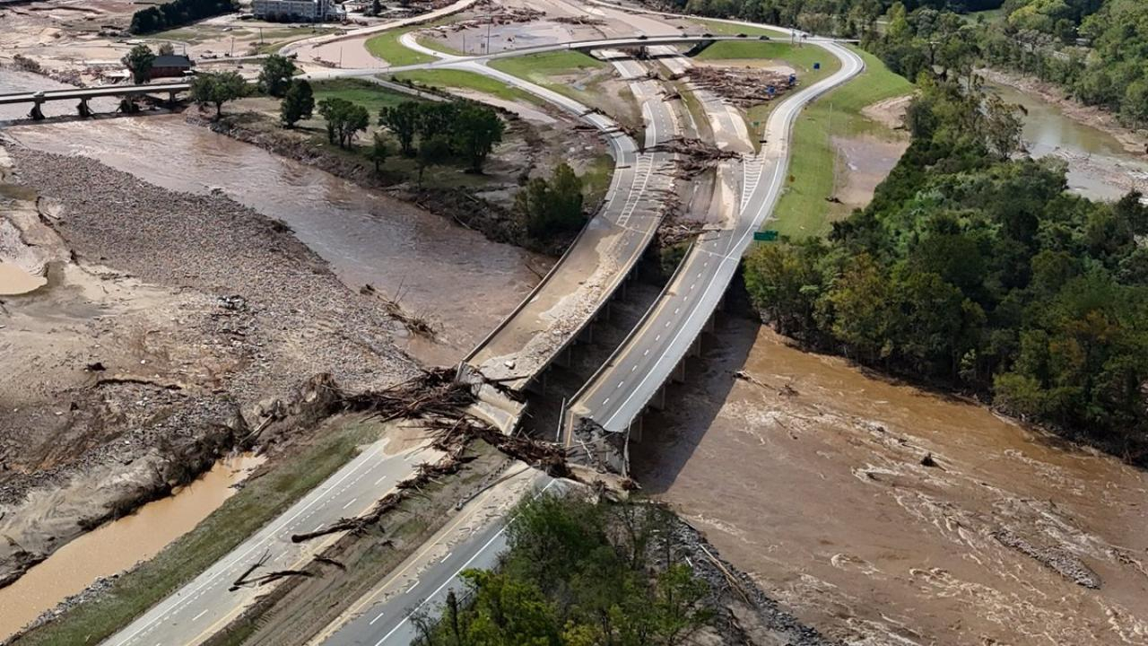
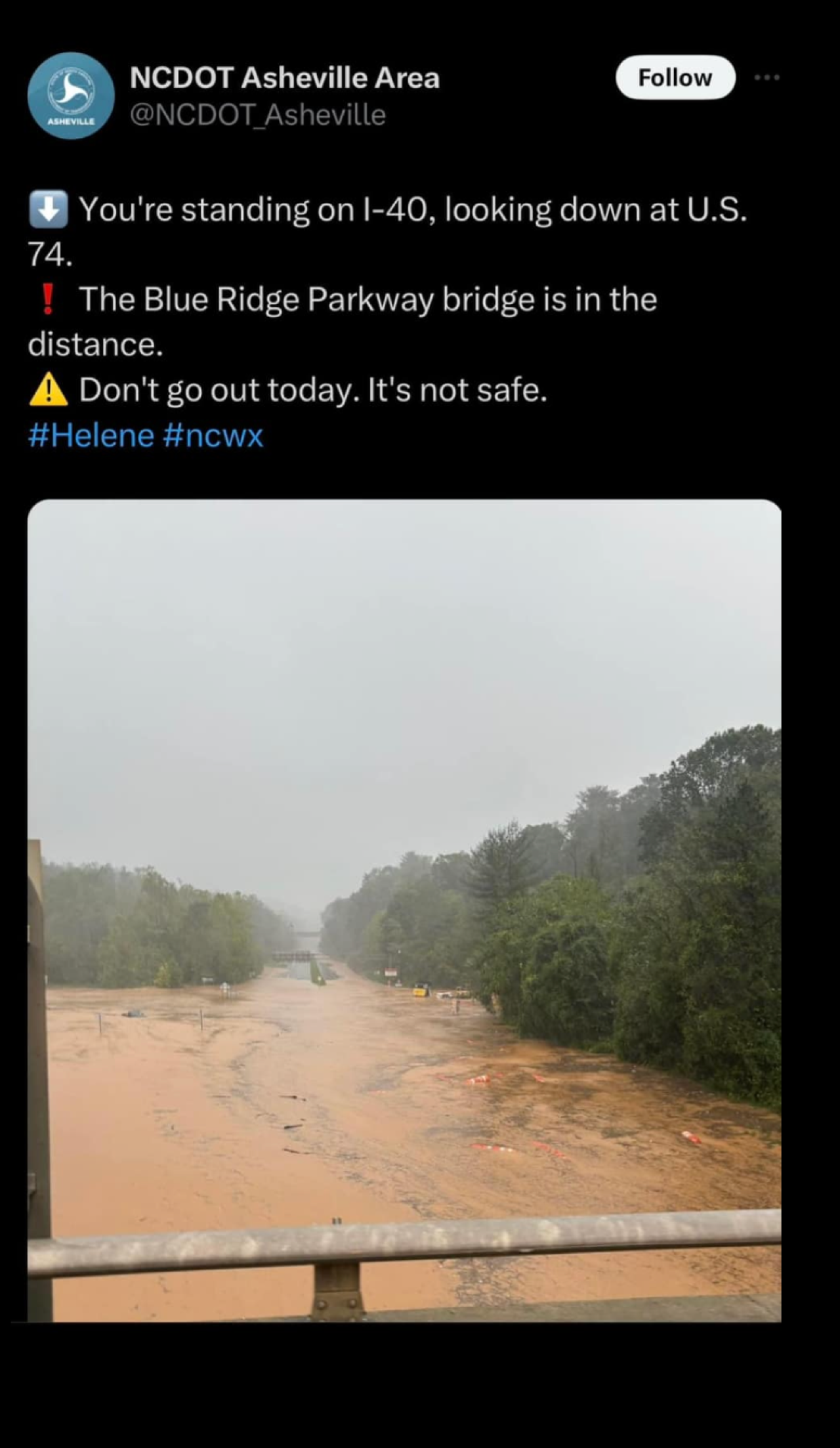
Interstate 40 through the mountains was closed at the state line. Authorities said the interstate had been washed out in several places, and it was far too early to tell how long it would take to repair the damage.
 Record flooding on the Pigeon River apparently undermined the ravine between Interstate 40 and the river in the Pigeon River Gorge, causing the collapse of two eastbound lanes in North Carolina near the Tennessee border. North Carolina Department of Transportation
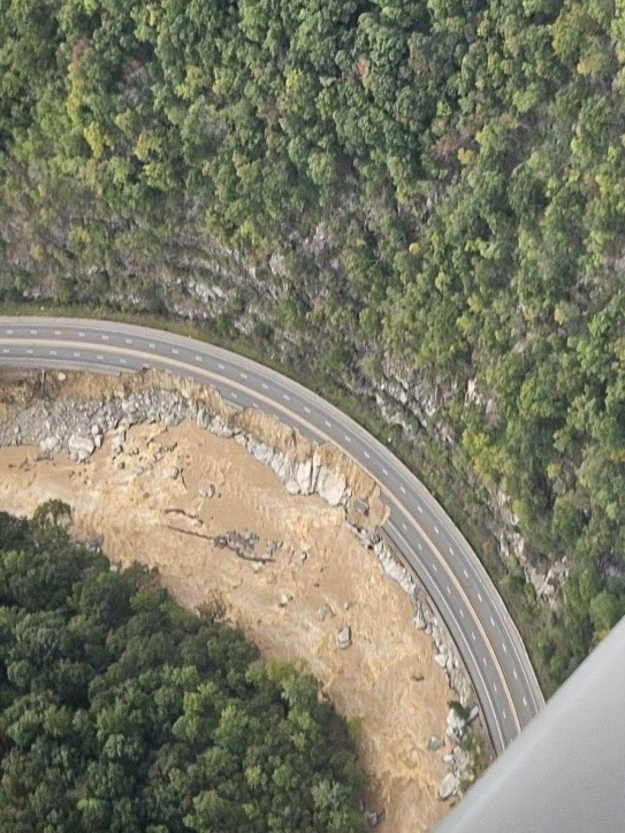
A particularly large mudslide near mile marker 3 on the North Carolina side of the state line apparently swept the eastbound lanes of I-40 into the Pigeon River, and a spokesperson for the North Carolina Department of Transportation said it could take several weeks to reopen the interstate.
Tennessee Gov. Bill Lee declared a state of emergency Friday afternoon as officials estimated that more than 100,000 people in the eastern third of the state had been left without power.
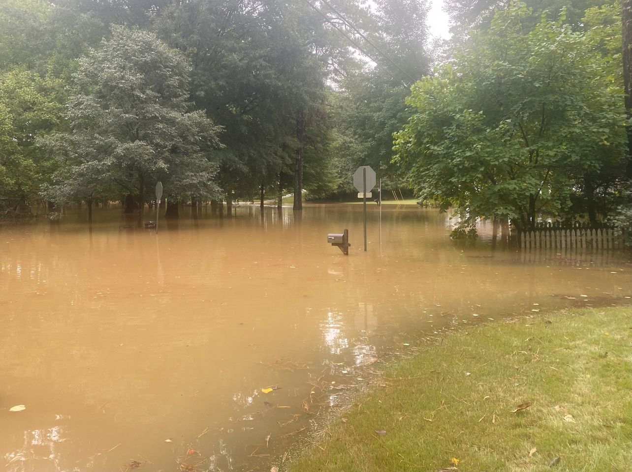
Throughout Western North Carolina, communities were cut off by torrents of muddy water that sluiced off mountains and prompted authorities to declare all major roads impassable.
In Asheville, city officials told the Citizen Times the storm had resulted in fatalities, but didn’t release specifics. CNN reported at least 50 fatalities related to Helene across the Southeast as of Saturday evening; the New York Times reported at least 60 deaths.
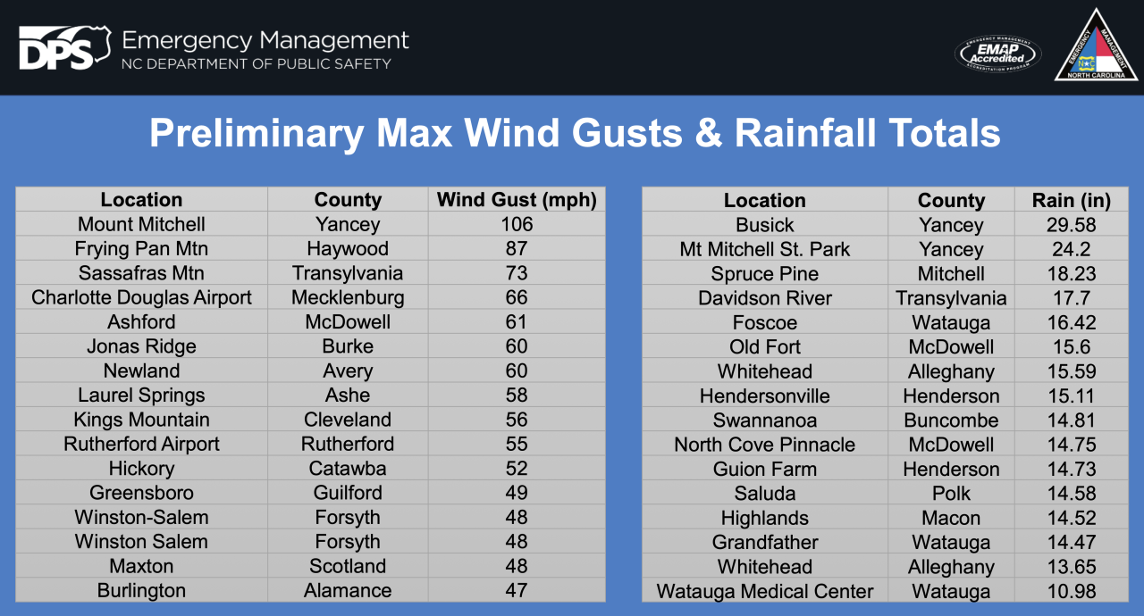
Meteorologist Kyle Snowdin of the National Weather Service said Helene dumped around 5 inches of rain on the East Tennessee Valley but weather stations in North Carolina registered between 10 and 20 inches of precipitation.
The event was made worse by a series of thunderstorms that had soaked the region earlier in the week, he said.
In addition to the record-setting rainfall, much of the region experienced sustained winds of 40 to 60 mph that toppled trees and power lines, he said.
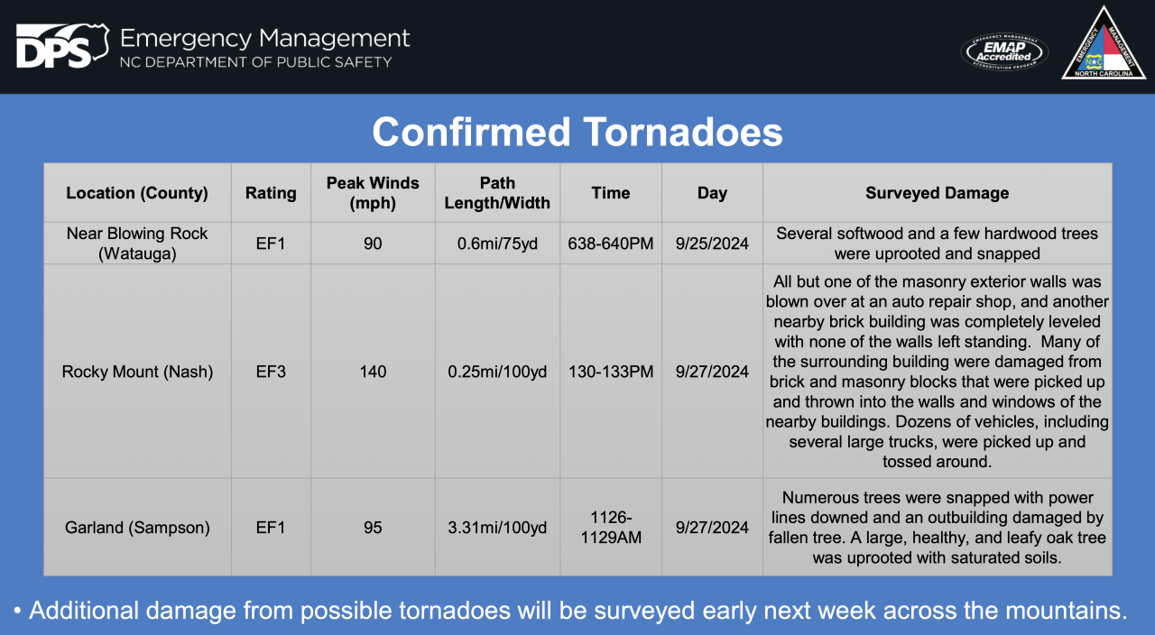
Three tornadoes were confirmed in North Carolina.
The Pigeon River in Newport crested at 28.9 feet early Saturday morning, Snowdin said. Previously, the highest water level ever recorded for the Pigeon at Newport was 23.5 feet in 1902.
“We absolutely toppled a very longstanding historic crest,” Snowdin said.
As Helene approached, several aging dams in the region — already near or at capacity — became a great concern to local authorities and downstream populations. This applied particularly to Duke Energy’s Lake Lure Dam on the Rocky Broad River and it’s Walters Dam (locally known as Waterville dam) on the Pigeon River.
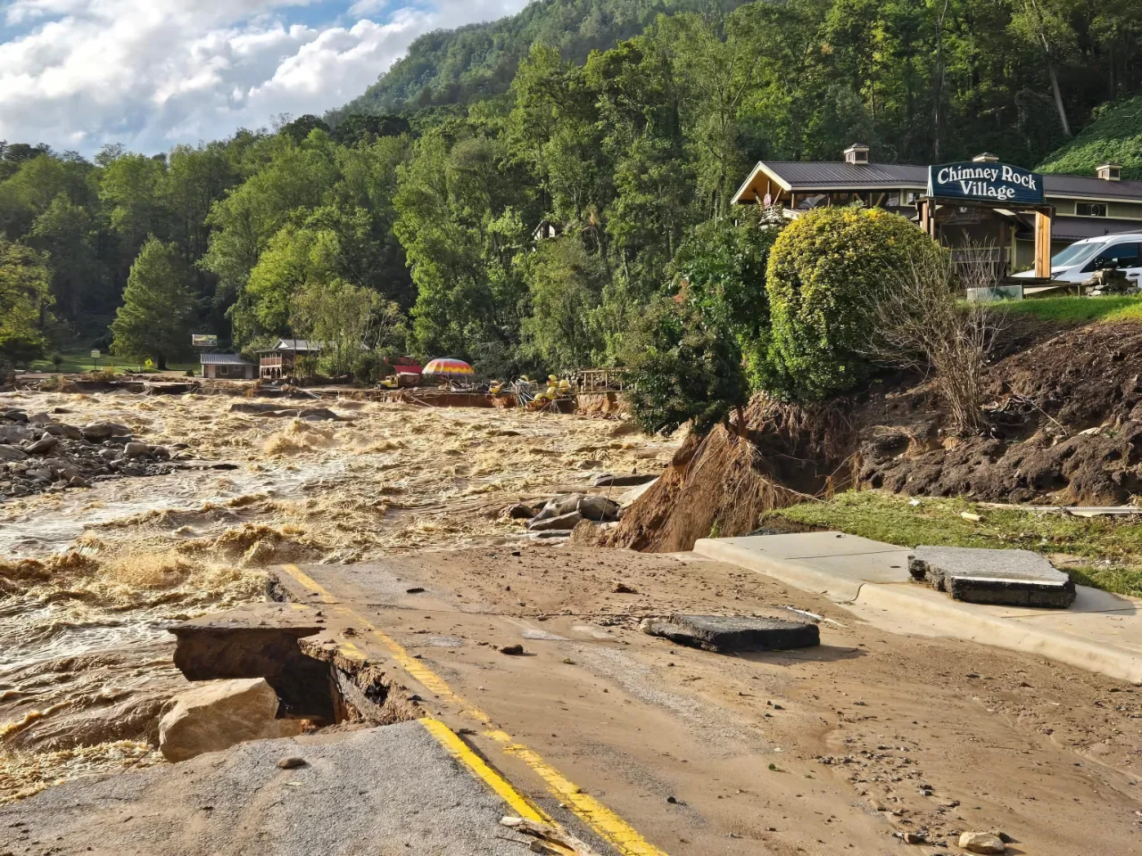 High waters swept away much of Chimney Rock Village, the popular hiking destination above Lake Lure of Dirty Dancing renown. No cell service or power!
 ![]() Van Xan
Van Xan
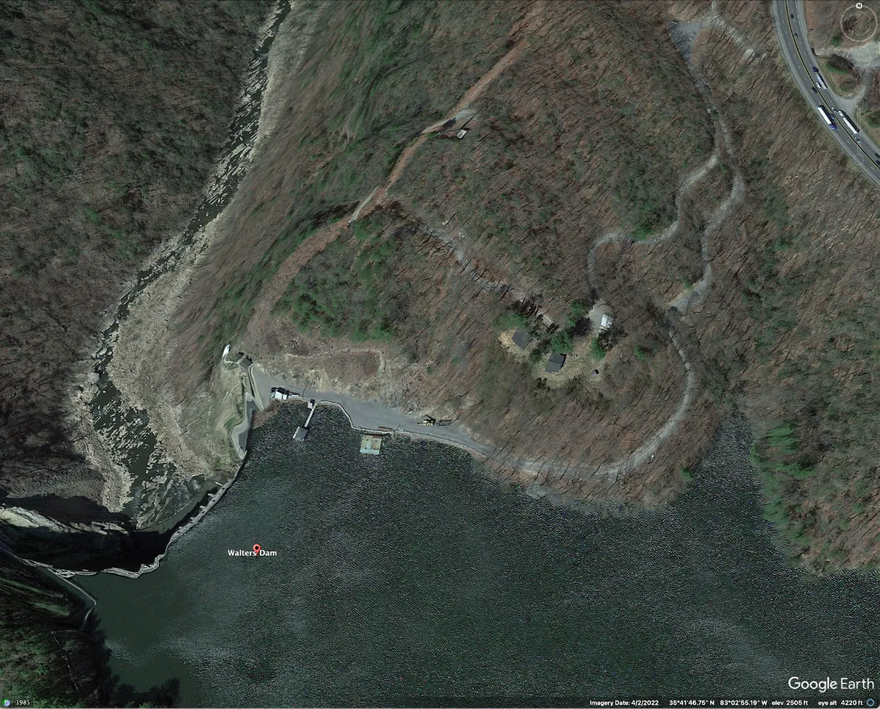 Waterville Lake (shown here during a period of low flow) is about halfway between Asheville and Newport. Travelers may notice it along the south-west side of I-4O.
Nolichucky Dam, was of primary concern too because it is also above Newport, toward the east. It was among those dams being closely watched by TVA officials, who issued a series of warnings during the event.
As of Saturday afternoon, a flood watch was still in effect along the Nolichucky due to the possibility the river’s namesake dam could break, said Snowdin.
“We haven’t had any dam failures, but if something like that happened it would be catastrophic, even beyond what’s already occurred,” he said.
When the Pigeon and French Broad rivers overtopped their banks starting early Friday afternoon, the water inundated numerous homes and forced residents of Newport to hurriedly seek shelter from the swiftly rising floodwaters.
Cocke County Mayor Rob Mathis announced at one point that the Waterville Dam in North Carolina had collapsed. Residents fled, businesses closed and inmates from the county jail were moved under armed guard to Sevier and Jefferson counties.
A little over an hour later, authorities determined the purported dam collapse was, in fact, a false report. The evacuation orders remained in effect, however, as sections of Newport were overwhelmed by several feet of rushing water.
The flooding also forced the Newport Utilities Board to shut down its wastewater treatment plant, and a Boil Water Advisory was issued to the district’s customers.
Flood advisories remained in effect for the Pigeon and the French Broad, as well as for Douglas Lake, which receives the waters of all three rivers.
In the small towns of Elizabethton and Roan Mountain in Carter County, the deluge forced scores of residents to seek shelter at churches, schools and other public buildings.
Police and fire departments from several East Tennessee counties responded to urgent requests for mutual aid, sending several rescue teams to the beleaguered communities.
For instance, the Knoxville Fire Department sent eight swift water technicians, and the Knoxville Police Department deployed four officers trained in swift water rescue, as well as three boats.
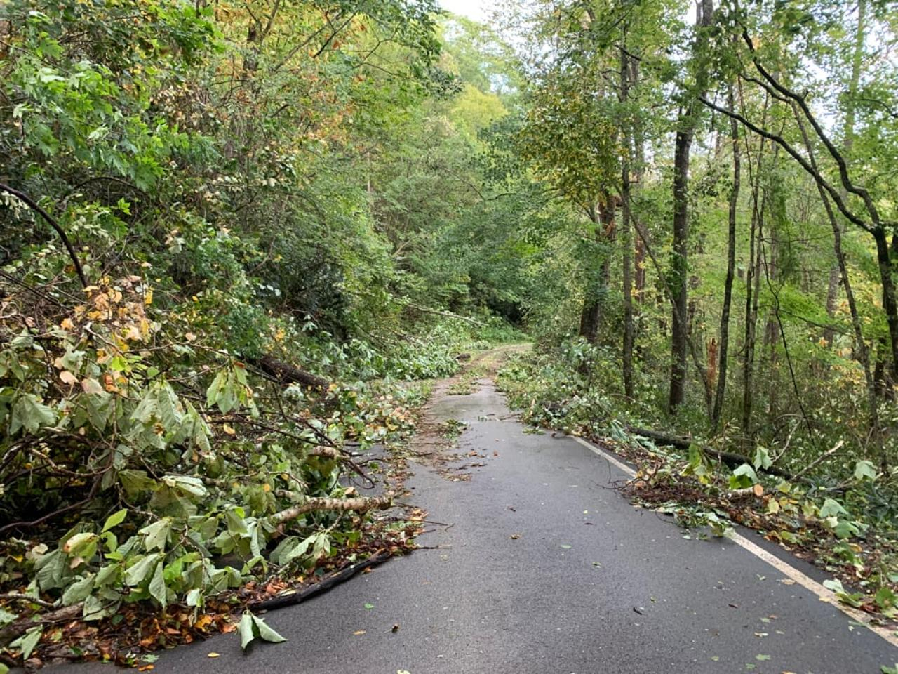
Transportation was also curtailed in the Great Smoky Mountains National Park, with Newfound Gap Road/US Highway 441 closed along with Little River Road from Elkmont to the Townsend Wye & Wear Cove.
Both the Oconaluftee Visitor Center and Kuwohi Visitor Center were slated to remain closed Saturday while rangers assessed damage to trails and campsites.
The national park recorded 9 inches of rain at Newfound Gap and Cataloochee Creek saw historic flooding with 9.5 feet of water, easily surpassing the 1963 flooding record of 8 feet.
While Knox County escaped the severe flooding seen to the north and east, high winds that downed trees and power lines caused nearly 27,000 KUB customers to lose power.
“Hurricane Helene brought high winds and heavy rainfall to the KUB service area, resulting in widespread and extensive damage to electric system infrastructure,” a KUB spokesperson said in a statement emailed to Hellbender Press late Friday night.
“KUB crews and other resources worked continuously overnight from Thursday into Friday, and have restored power to more than 20,500 customers so far today,” she said. “Crews will continue working overnight tonight and into the weekend until power is restored to all customers. At this time, approximately 6,400 customers remain without power.”
She added: “KUB is not yet able to provide an estimated restoration time as the extensive damage continues to be assessed while crews work to restore power.”
Update 9 p.m. Sept. 28
- The National Park Service and Appalachian Trail organizations are recommending that hikers cancel any attempts to hike the southern third of the trail for the foreseeable future. There are unverified reports that several iconic hiker hostels are closed due to damages and catastrophic flooding, including The Station at 19E and Mountain Harbour B&B in Roan Mountain; The Grove Hostel in Franklin; The Dancing Bear Inn in Damascus; and Uncle Johnny’s Nolichucky Hostel & Outfitter in Erwin. Hiker Ashley Langdon Luke posted an excellent suggestion on an Appalachian Trail Facebook page: “If you still want to come, see if you can find a way to volunteer in one of these devastated communities or reach out to the local trail club to see what they need.”
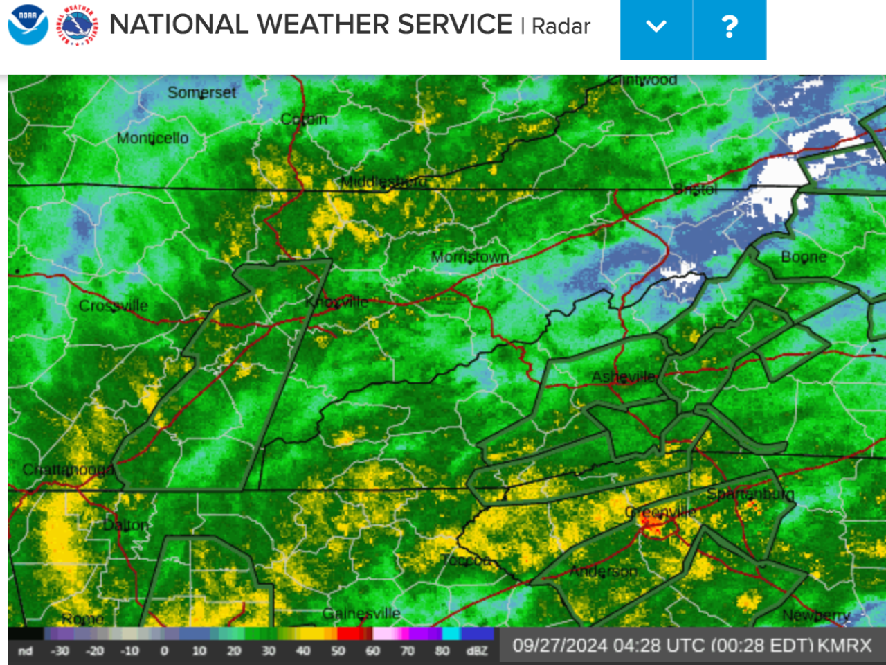
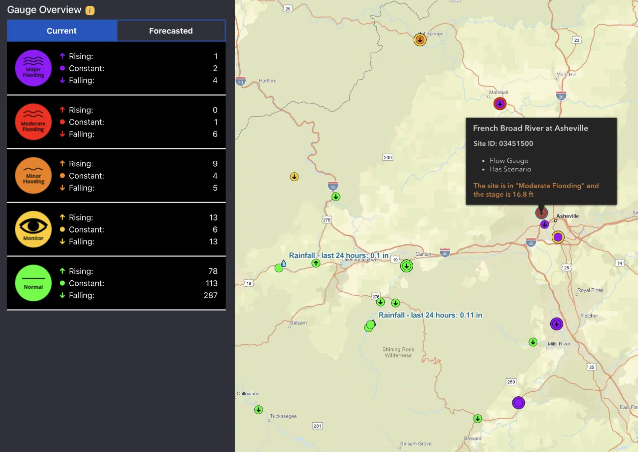 Although headwater streams are calming down again, many rivers are still at flood stages, which is particularly true for the French Broad, as shown by North Carolina’s Flood INundation Mapping & Alert Network. As Douglas Lake fills up, levels downstream of it in the French Broad and upper Tennessee may still rise. FINMAN
Touch the interactive map to view the current situation and zoom in or out to explore other areas.
-
Asheville and Buncombe County officials are receiving an overwhelming number of requests for news about missing friends and loved ones. In response, they have created this form. Fill it out and they will do their best to locate missing persons and update you as time and conditions allow.

- Augusta and the entire Savannah River Basin have been devastated by Helene, with numerous road closures and electrical outages expected to continue for a week or more. In response, Savannah Riverkeeper has created this map of the entire region affected by Helene — including all of Southern Appalachia — with layered information about stream height, power outages, first responder locations, gas stations and more.

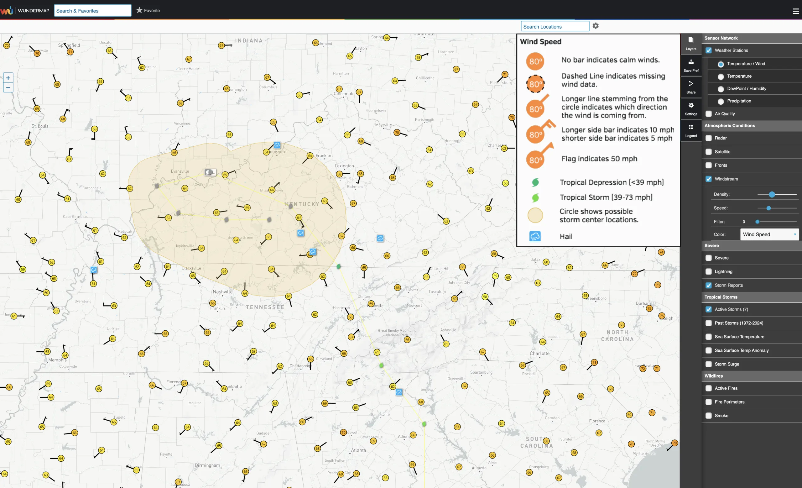 This Wundermap from Sept. 28 12:00 a.m. shows that there was still much turbulence at ground level; strong winds coming from all directions.
Touch the map to access the interactive map for the current time and preceding hours.
The original story and updates are below.
KNOXVILLE — Meteorologists at the National Weather Service regional office at Morristown on Thursday (Sept. 26) evening described approaching Hurricane Helene as an “historic setup for the Southern Appalachians that we haven’t seen in decades.”
The hurricane itself, which at about 11 p.m. made landfall on the rural Big Bend of Florida, is already breaking storm-surge and other records. It will have a widespread impact in coming hours and days well inland, traveling north across Georgia into the Tennessee Valley and along the spines and crests of the Southern Appalachians. It is projected to drop prodigious amounts of rain, especially across Western North Carolina, which was under a tropical storm warning at 11 p.m. Tropical storm conditions are possible in Knoxville as the remains of the storm head into the region, according to the weather service.
Helene is already affecting transportation, public works, commerce and personal lives and Hellbender Press will be here to provide as many updates as we can throughout the storm, aggregated from multiple sources. We are focusing on the breadth and depth of the storm as reported largely by citizen scientists and those who share their expertise via social media and use of open-source applications.
Update 9:30 p.m. Sept. 27
 Touch the map to see present alerts.
- Multiple sources report that USA Raft Adventure Resort along the Nolichucky River was destroyed after the river reached unprecedented levels on Friday:
“USA Raft is gone gone,” Katie Prince told Hellbender Press via social media. “The Bridge at Johnny’s is gone. Big Rock is about 30’ underwater. Houses, cars, large propane tanks floating down the river. Gauge blew out at 92,500 [cubic foot per second]; speculation is it reached 150,000 today.”
 Nolichucky River gauge at Embreeville stopped recording at 11:30 a.m. To accurately determine how hight the water level rose will require on-site expert investigation. The all-time record for this location is 24 ft on May 21, 1901. 2nd highest is 21.52 ft, Nov. 6, 1977. However both historic numbers predate the current gauge and are associated with some degrees of uncertainty.
- Mobile homes floating down the Nolichucky River near Roan Mountain. Video provided by Amber Harkleroad Waycaster. She was evacuated shortly afterward. “This is our backyard. Water has a ways to get to us still, but pray guys! We’ve seen water rescue and homes destroyed.”
- Pigeon River at Hartford also flooded rafting outfitters. When the numbers are added up, it could be a dark day for the regional recreational whitewater industry.
- Jon Mitchell of Johnson City said he lost two RVs to the Nolichucky; they were parked near the now-evacuated Unicoi Hospital. He said the level of damage is astonishing. He created a new verb: The area, he said, had been “FEMAd.”
 Residents of Ripshin Ridge near Roan Mountain had to chainsaw their way to main roads. Buzz Trexler
Update 7 p.m. Sept. 27
- Tennessee Emergency Management Agency released this update Friday afternoon:
“Unicoi County Hospital is inundated and patients and staff are being evacuated; however, the evacuations are complicated by the Nolichucky River, which is rapidly rising and full of debris. Local officials in Washington County have told Embreeville residents to evacuate. Hawkins County officials have told residents to shelter-in-place. Northeast Tennessee continues to be impacted by flooding. If you live in a flood prone area, please find higher ground, evacuate if you are told to, and stay informed of the evolving situation. Sheltering locations can be found on TEMA’s website. Many roadways have been impacted by flooding. Before going out, visit TDOT’s SmartWay website.” -
In addition to the landslide affecting Interstate 40 through the Pigeon River Gorge, I-26 is closed. Per NCDOT: “Catastrophic Transportation Impacts In Western NC
“I-40 and I-26 are impassable in multiple locations. All roads in Western North Carolina should be considered closed. Motorists should not travel in this area, should not attempt to drive through standing water, and must respect barricades and road closure signs.”
Update 6 p.m. Sept. 27
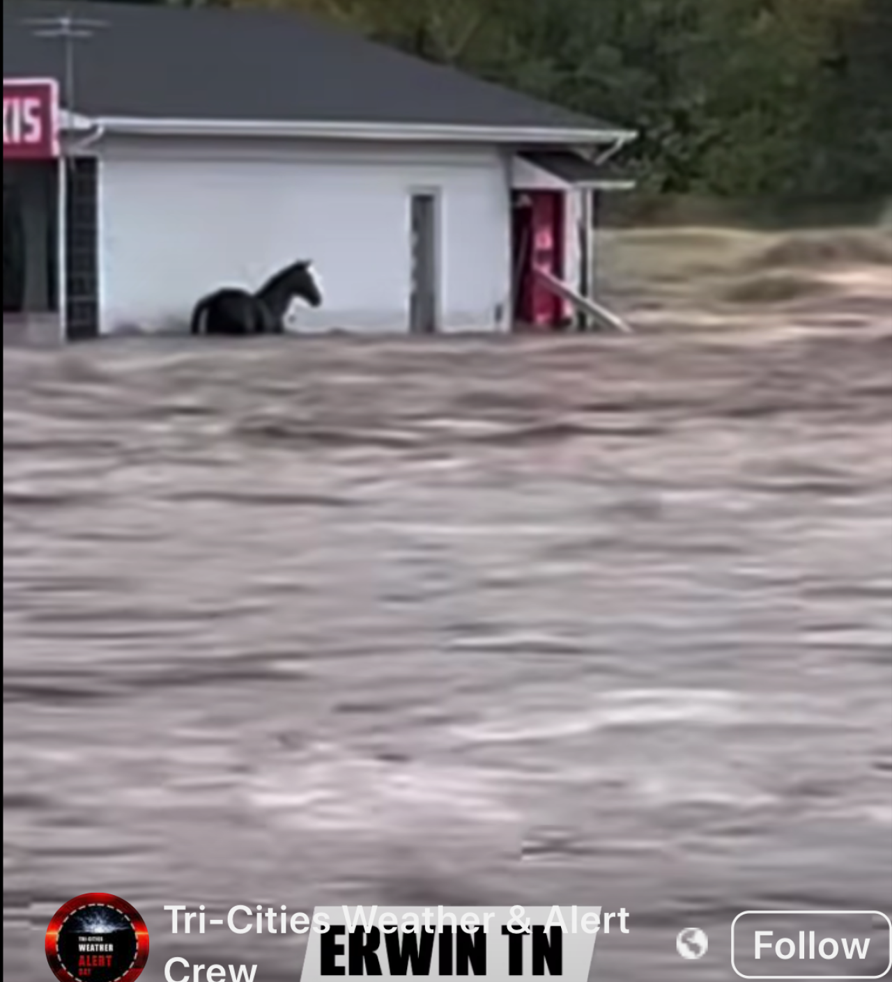
- There are reportedly massive floods under way in northeastern Tennessee, including Erwin and Elizabethton. The Tennessee Holler shared video of terrified animals amid extreme floodwaters, and indicated the National Guard may be activated. Patients evacuated Unicoi County hospital.
 Touch the image to view the video.
Update: 5 p.m. Sept. 27
- Carolina Public Press: “Much of the worst damage in North Carolina has centered on Asheville in Buncombe County, the largest population center in western counties and a major convergence point for creeks and rivers.
- “There’s a lot of things underwater right now,” State Sen. Julie Mayfield, D-Buncombe, told Carolina Public Press. “They’re predicting this will be the worst flooding we’ve had in more than a century.”
- “What we are seeing is unlike anything anyone alive has ever seen here in this area,” Buncombe County Manager Avril Pender said at a Friday morning press conference.
- The Tennessee Valley Authority posted this on its X feed: “Tributary lake levels are rapidly rising, especially at Watauga, Douglas, South Holston, Fontana, and Cherokee. Expect high river flows below the dams as we maximize generation and supplement with sluicing and spilling to move this water through our system. Get real-time lake level info: tva.me/ll8o50TxfAb.”
- While most of North Georgia is recovering from Helene, Rabun County suffered major damage. A failure at Mathis Dam caused significant flooding in the south end of the county, and many roads remain blocked. The full extent of the destruction may not be known for days.
- The city of Asheville issued a boil-water advisory.
- Blogger Thunderpig has the latest on WNC power outages.
- The Smoky Mountain News reports that some of the worst flooding in WNC is in the Canton and Clyde areas of Haywood County along the Pigeon River.
- The CItizen TImes reports that Asheville police will enforce a citywide curfew beginning tonight.
Update 4 p.m. Sept. 27
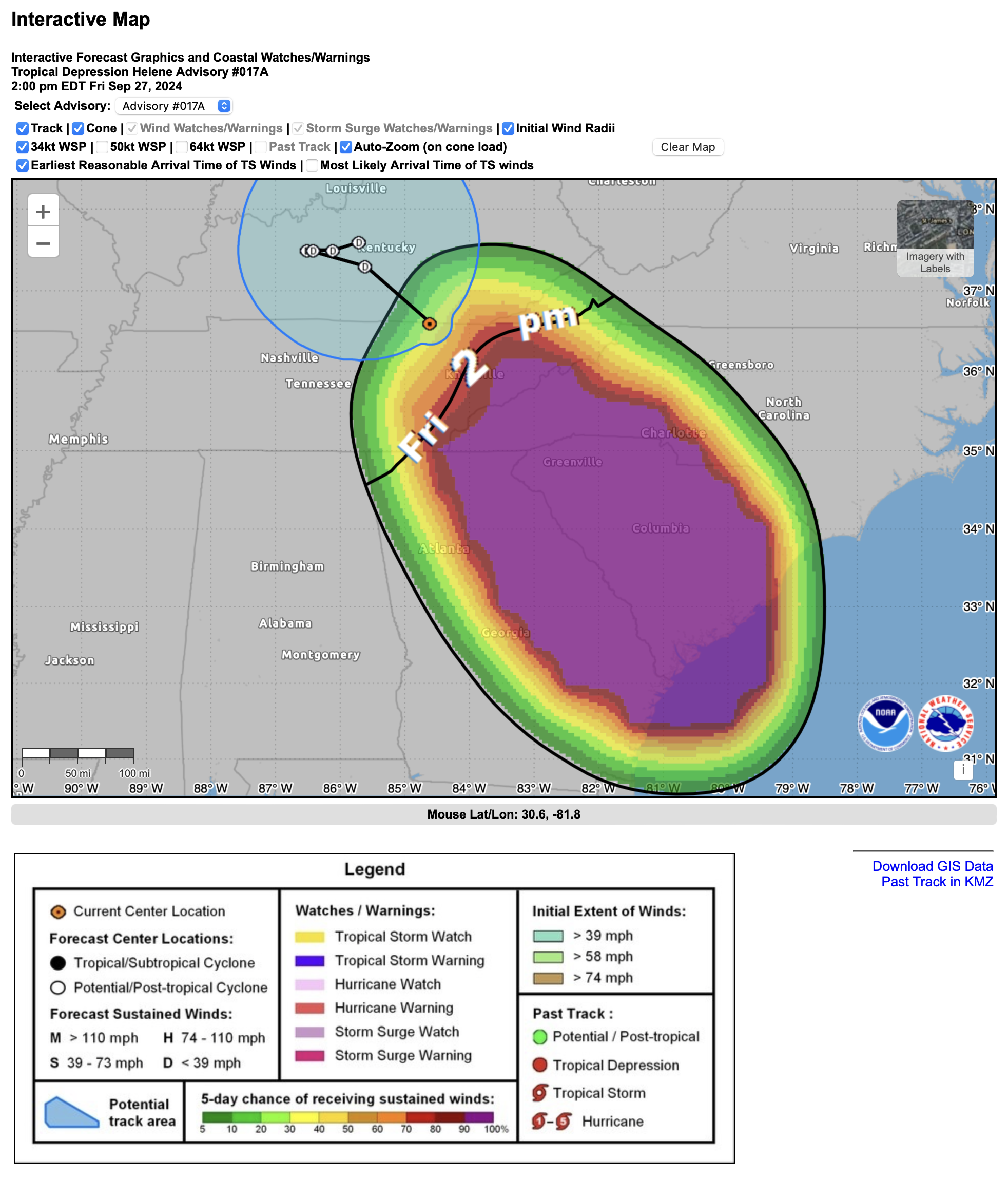
- Helene is now a post-tropical depression centered over Kentucky.
- Chattahoochee Riverkeeper posted this on Facebook out of Georgia: “Parts of the Chattahoochee River Basin experienced major flooding as Hurricane Helene moved across the southeast today. The Chattahoochee River near CRK’s metro Atlanta office has risen by at least 25 feet since Tuesday. The storm has passed, but floodwaters continue rising in some areas. We hope everyone is staying safe and our hearts go out to all who have been impacted by the storm.”
 Chattahoochee River at 14th St Bridge in Columbus, Georgia. Chattahoochee Riverkeeper
 Flooding near Atlanta Memorial Park. Chattahoochee Riverkeeper
- Rutherford County emergency managers posted this on Facebook: “(N.C.) 9-27-24 at 1:30 PM: Water is cresting the Dam and flowing around the side walls. Structural supports have been compromised but the Dam wall is currently holding. Evacuations have occurred from the Dam to Island Creek Road. Evacuation sirens are sounding downstream of the Dam. Emergency personnel are working with the structural engineers and are going house to house to ensure all citizens have been evacuated. Evacuees are being transported temporarily to Ingles in Lake Lure. Text AlertRC to 888777 to get emergency updates.
- A rockslide has closed I-40 in both directions near the North Carolina-Tennessee line, according to multiple media reports. This could be one of the enduring legacies of this storm. The North Carolina Department of Transportation said “all roads in Western North Carolina should be considered closed.”
-
WBIR of Knoxville has a good report on the interstate closure in the Pigeon River Gorge.
Update: 2 p.m. Sept. 27
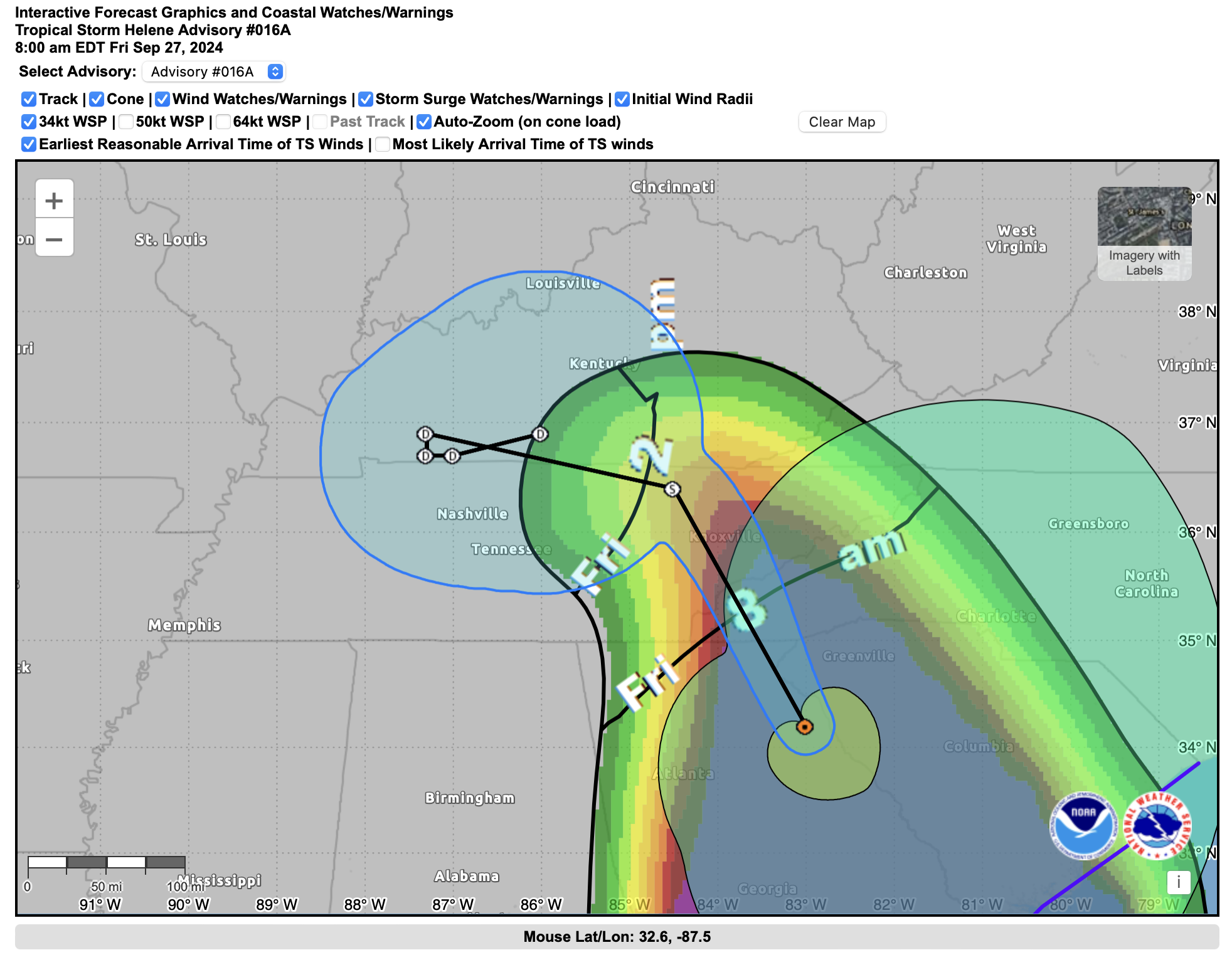
 Touch the map to interact with its latest updates. National Hurricane Center
Update: 12 p.m. Sept. 27
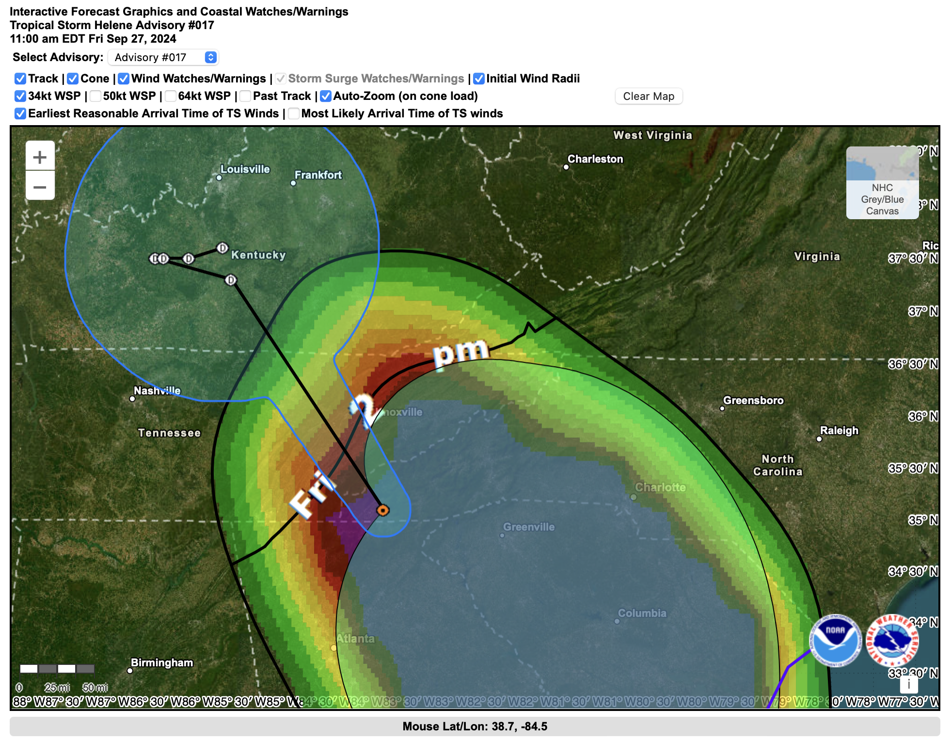
- Tropical Storm Helene is centered roughly over Murphy, N.C. in the Valley River basin. It is moving north and expected to degrade to a low and shift its track toward Kentucky. Tropical storm conditions are possible in the greater Knoxville area.
-
Winds are on the upswing in Knox County and rain is sheeting horizontally across streets already covered with woody debris. A high wind warning remains in effect for the Knoxville metro area and East Tennessee through 8 p.m. Expect wind gusts up to 45 mph. Power outages are a primary concern, as are the lingering effects of flooded roadways and steadily rising creeks, streams and rivers. Never try to drive through standing or running water, and keep an eye on children and pets near drainage areas and high, swift-moving water.
-
Nearly 3 million utility customers are without power in the affected Southeast states; outages are steadily mounting in East Tennessee.
-
Atlanta, like Tallahassee, was spared the worst predicted affects of Helene. Widespread flooding, downed trees, and blackouts mean expanded closures. All schools and many business are closed. Amtrak has canceled all trains, and many flights have been canceled or delayed.
Update: 11:00 a.m. Sept. 27
Update: 8:00 a.m. Sept. 27
-
David Hotz, Science and Operations Officer with the Morristown Weather Forecast Office of the National Weather Service, explains why the predicted track of Hurricane Helene has shifted westward from earlier projections: “There is a deep area of low pressure across west Tennessee. The circulation around this low will pull the remains of Helene back to the west into this area of low pressure. Something similar happened with Hurricane Sandy.”
 This graphic shows the very warm waters that fueled Hurricane Helene. NASA
Update: 4:30 a.m. Sept. 27
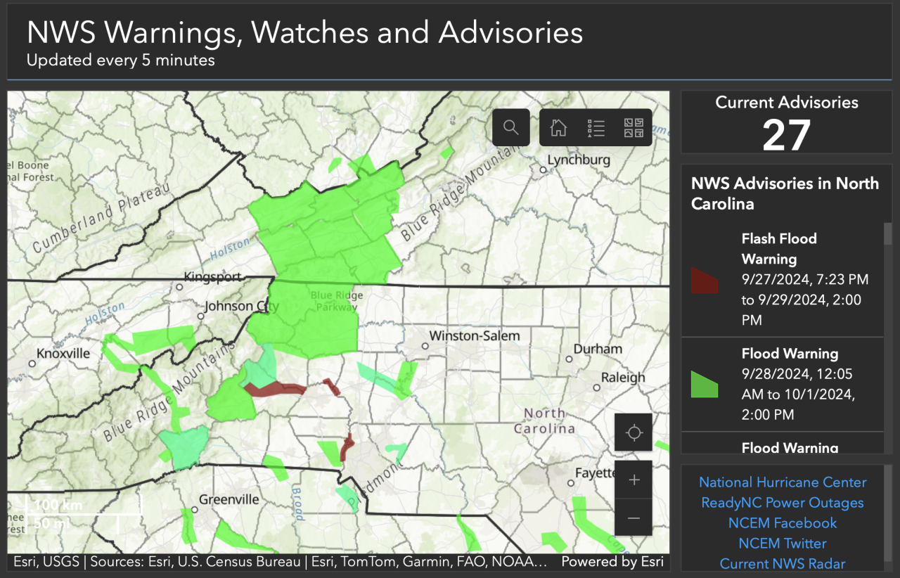
- Here’s a look at the plethora of current National Weather Service warnings in place across the Southern Appalachians:
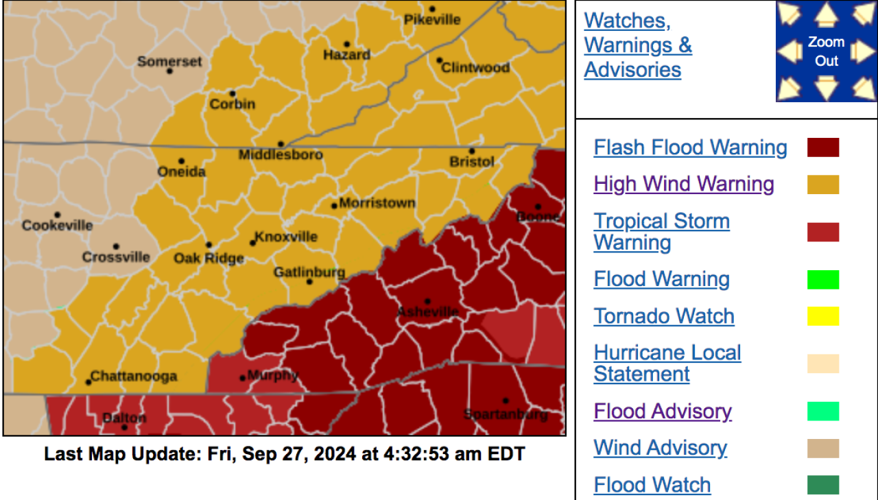
- The National Weather Service has declared a flash flood emergency for Haywood County in Western North Carolina. The warning extends through 10:15 a.m. Up to 20 inches of total rain are possible with the remnants of Helene and preceding rain events. The Weather Channel reports multiple water rescues are under way. Flash flood warnings are also in place in Graham and Swain counties.
Update: 3:30 a.m. Sept. 27
- At least 2 million customers are without power in Georgia, Florida and the Carolinas, according to PowerOutage.us.
-
Winds are beginning to pick up in the Knoxville area. The weather service warns of sustained winds in the 30-mph range with gusts of up to 60 mph. A high wind warning is in effect through 8 p.m. Power outages are likely, as fully-leafed trees topple in sodden soil.
- Multiple school districts are closed in the Knoxville area ahead of the expected arrival of the remnants of Helene.
- WNC Scanner Traffic is a social media site based in Macon County, N.C. It is currently crowd-sourcing and reporting on first-responder radio traffic and weather conditions, even in the wee hours.
- Check out this video of raging waters at Laurel Falls in the Great Smokies courtesy of Dana Soehn via social media.
Update: 2:30 a.m. Sept. 27
-
A flood warning is in effect for most of south and central East Tennessee; a flash-flood warning is in effect for much of the Knoxville area.
-
In addition to traditional point sources of weather data maintained by government agencies, such as airports, WeatherUnderground hosts a global network of weather sensors and data stations, some of which can probably be traced to be your neighborhood.
-
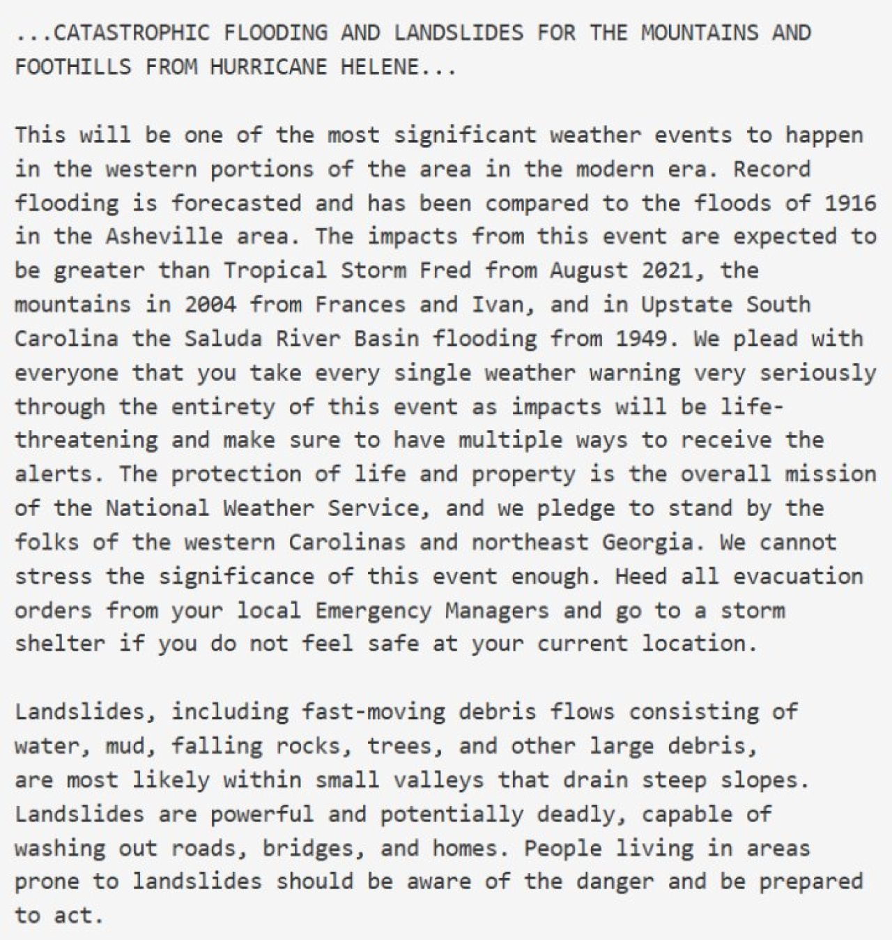
The National Weather Service in Greenville released this ominous and unusually personal message Thursday afternoon:
-
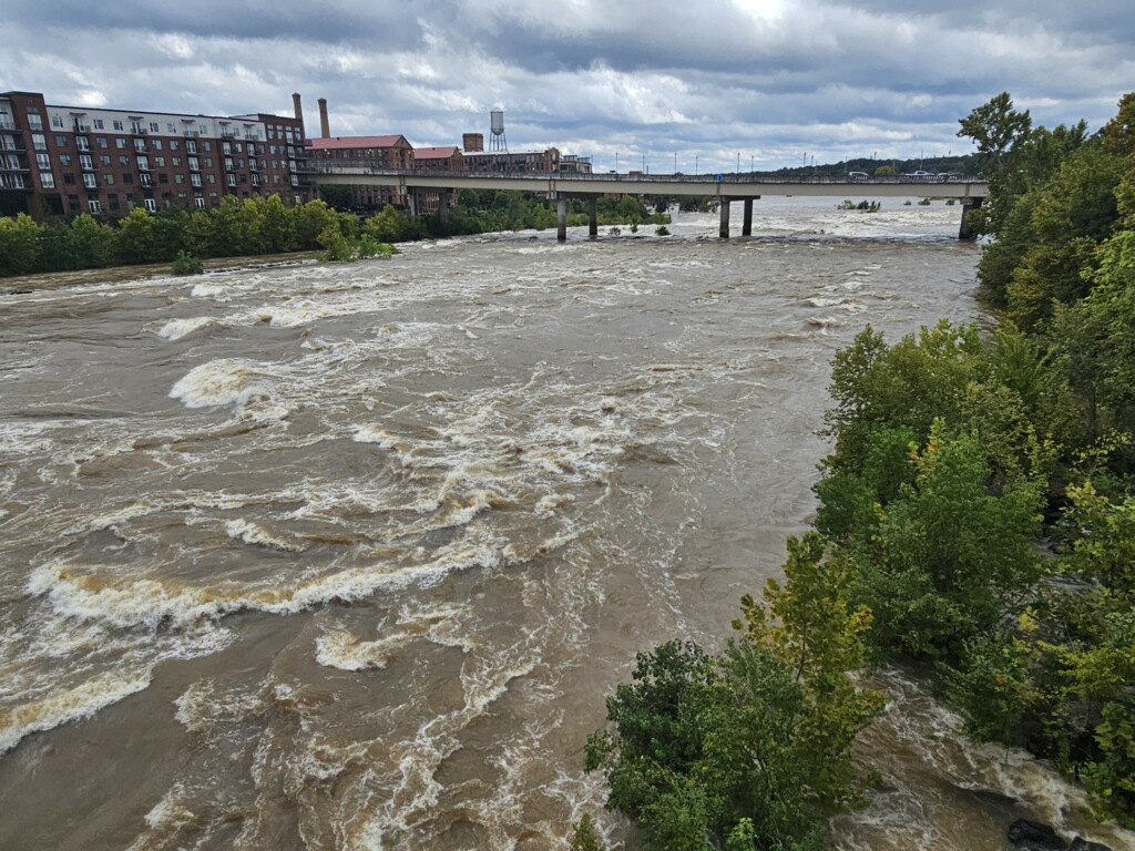
WLOS in Asheville reports widespread flooding, including in the city’s River Arts District along the French Broad River.
-
Per its X feed, Haywood County (N.C.) Emergency Services opened a shelter at the Armory in Clyde.
Update: 12:30 a.m. Sept. 27
- A steady stream of moderate to heavy rain is streaming from the southeast into the Southern Appalachians. A major factor in the high threat posed by the heavy rain is preceding days of rain that saw at least 2-4 inches fall in many areas, with locally very higher amounts
- The folks over at Ray’s Weather have been diving deep, and reliably, into the forecasts of Western North Carolina and the Asheville area for years. They foresee, like the National Weather Service, an historic rain event. It’s a business, but began in the backyard.
- Turley writes that the “French Broad flooding looks to go to record heights in several spots. The Swannanoa River at Biltmore is projected to go well over record flood stage.” Asheville journalist Jason Sandford, who runs the Ashevegas blog, said areas prone to flooding — such as Biltmore Village — had begun to flood even before the heavier rains began moving into the area.
- The Georgia Mountains and Southern Appalachia Facebook page cracked wise:

- The Atlanta Journal Constitution dropped its paywall as a public service during the storm, which entered Georgia as a category 2 hurricane.
- More than one million customers are without power in Florida, Georgia, and the Carolinas, according to U.S. Power Outage Map. The number only applies to individual accounts, so multiple people are often affected.
- In the northeast Atlanta neighborhood of Medlock Park, the South Fork of Peachtree Creek has already risen some 20 inches above the banks. Long-time residents are saying this is the worst they’ve seen in 20 years — and the really hard rain still hasn’t begun. They expect many homes in the area to flood tonight.
- hurricane helene local impacts
- hurricane helene knoxville
- is hurricane helene coming here
- dean turley
- rays weather
- french broad river asheville
- french broad river
- biltmore village
- jason sandford
- helena updates knoxville
- ashevegas
- weather underground
- citizen data collection
- citizen science
- knoxville weather
- hellbender press hurricane coverage
- clyde shelter helene
- laurel falls video
- dana soehn
- wnc scanner traffic
- atlanta helene
- haywood county water rescues
- weather data collection
- social media hurricanes
- natural disaster social media
- high wind warning knoxville
- atlanta hurricane
- i40 closed
- interstate 40
- pigeon river gorge
- pigeon river flooding
- chattahoochee riverkeeper
- tva helene
- watauga reservoir
- tva dams
- tva hydroelectricity
- erwin
- elizabethton flooding
- unicoi county hospital evacuated
- usa raft adventure resort
- nolichucky
- nolichucky flooding
- ripshin ridge
- roan mountain flooding
- buzz trexler
- town of roan mountain
- flood september 2024
- savannah riverkeeper helene map
- helene flooding map
- augusta helene
- gas stations affected by helene
- appalachian trail
- appalachian trail helene
- appalachian trail hostels helene
- at closures helene
- kingsport times news
- citizen times
- buncombe county
- buncombe county flooding
- asheville flooding deaths
- i26 closed
- is i26 closed?
- helene photos
- waterville dam
- lake lure
- how many killed in asheville flood
- erwin, tenn,
- usa raft
- debris burning
- helene debris
- douglas lake
- nolichucky appalachian trail flooding
- tema
- carter county
- fema
- unicoi county
- environmental justice
- hartford
- east tennessee rafting
Updated again: Deadly Hurricane Helene heads for the mountains — The first 24 hours of Hellbender Press reporting
KNOXVILLE — Meteorologists at the National Weather Service regional office at Morristown on Thursday (Sept. 26) evening described approaching Hurricane Helene as an “historic setup for the Southern Appalachians that we haven’t seen in decades.”
The hurricane itself, which at about 11 p.m. made landfall on the rural Big Bend of Florida, is already breaking storm-surge and other records. It will have a widespread impact in coming hours and days well inland, traveling north across Georgia into the Tennessee Valley and along the spines and crests of the Southern Appalachians. It is projected to drop prodigious amounts of rain, especially across Western North Carolina, which was under a tropical storm warning at 11 p.m. Tropical storm conditions are possible in Knoxville as the remains of the storm head into the region, according to the weather service.
Helene is already affecting transportation, public works, commerce and personal lives and Hellbender Press will be here to provide as many updates as we can throughout the storm, aggregated from multiple sources. We are focusing on the breadth and depth of the storm as reported largely by citizen scientists and those who share their expertise via social media and use of open-source applications.
Update 9:30 p.m. Sept. 27
Touch the map to see present alerts.
- Multiple sources report that USA Raft Adventure Resort along the Nolichucky River was destroyed after the river reached unprecedented levels on Friday:
“USA Raft is gone gone,” Katie Prince told Hellbender Press via social media. “The Bridge at Johnny’s is gone. Big Rock is about 30’ underwater. Houses, cars, large propane tanks floating down the river. Gauge blew out at 92,500 [cubic foot per second]; speculation is it reached 150,000 today.”
Nolichucky River gauge at Embreeville stopped recording at 11:30 a.m. To accurately determine how hight the water level rose will require on-site expert investigation. The all-time record for this location is 24 ft on May 21, 1901. 2nd highest is 21.52 ft, Nov. 6, 1977. However both historic numbers predate the current gauge and are associated with some degrees of uncertainty.
- Mobile homes floating down the Nolichucky River near Roan Mountain. Video provided by Amber Harkleroad Waycaster. She was evacuated shortly afterward. “This is our backyard. Water has a ways to get to us still, but pray guys! We’ve seen water rescue and homes destroyed.”
- Pigeon River at Hartford also flooded rafting outfitters. When the numbers are added up, it could be a dark day for the regional recreational whitewater industry.
- Jon Mitchell of Johnson City said he lost two RVs to the Nolichucky; they were parked near the now-evacuated Unicoi Hospital. He said the level of damage is astonishing. He created a new verb: The area, he said, had been “FEMAd.”
Residents of Ripshin Ridge near Roan Mountain had to chainsaw their way to main roads. Buzz Trexler
Update 7 p.m. Sept. 27
- Tennessee Emergency Management Agency released this update Friday afternoon:
“Unicoi County Hospital is inundated and patients and staff are being evacuated; however, the evacuations are complicated by the Nolichucky River, which is rapidly rising and full of debris. Local officials in Washington County have told Embreeville residents to evacuate. Hawkins County officials have told residents to shelter-in-place. Northeast Tennessee continues to be impacted by flooding. If you live in a flood prone area, please find higher ground, evacuate if you are told to, and stay informed of the evolving situation. Sheltering locations can be found on TEMA’s website. Many roadways have been impacted by flooding. Before going out, visit TDOT’s SmartWay website.” -
In addition to the landslide affecting Interstate 40 through the Pigeon River Gorge, I-26 is closed. Per NCDOT: “Catastrophic Transportation Impacts In Western NC
“I-40 and I-26 are impassable in multiple locations. All roads in Western North Carolina should be considered closed. Motorists should not travel in this area, should not attempt to drive through standing water, and must respect barricades and road closure signs.”
Update 6 p.m. Sept. 27
- There are reportedly massive floods under way in northeastern Tennessee, including Erwin and Elizabethton. The Tennessee Holler shared video of terrified animals amid extreme floodwaters, and indicated the National Guard may be activated. Patients evacuated Unicoi County hospital.
Touch the image to view the video.
Update: 5 p.m. Sept. 27
- Carolina Public Press: “Much of the worst damage in North Carolina has centered on Asheville in Buncombe County, the largest population center in western counties and a major convergence point for creeks and rivers.
- “There’s a lot of things underwater right now,” State Sen. Julie Mayfield, D-Buncombe, told Carolina Public Press. “They’re predicting this will be the worst flooding we’ve had in more than a century.”
- “What we are seeing is unlike anything anyone alive has ever seen here in this area,” Buncombe County Manager Avril Pender said at a Friday morning press conference.
- The Tennessee Valley Authority posted this on its X feed: “Tributary lake levels are rapidly rising, especially at Watauga, Douglas, South Holston, Fontana, and Cherokee. Expect high river flows below the dams as we maximize generation and supplement with sluicing and spilling to move this water through our system. Get real-time lake level info: tva.me/ll8o50TxfAb.”
- While most of North Georgia is recovering from Helene, Rabun County suffered major damage. A failure at Mathis Dam caused significant flooding in the south end of the county, and many roads remain blocked. The full extent of the destruction may not be known for days.
- The city of Asheville issued a boil-water advisory.
- Blogger Thunderpig has the latest on WNC power outages.
- The Smoky Mountain News reports that some of the worst flooding in WNC is in the Canton and Clyde areas of Haywood County along the Pigeon River.
- The CItizen TImes reports that Asheville police will enforce a citywide curfew beginning tonight.
Update 4 p.m. Sept. 27
- Helene is now a post-tropical depression centered over Kentucky.
- Chattahoochee Riverkeeper posted this on Facebook out of Georgia: “Parts of the Chattahoochee River Basin experienced major flooding as Hurricane Helene moved across the southeast today. The Chattahoochee River near CRK’s metro Atlanta office has risen by at least 25 feet since Tuesday. The storm has passed, but floodwaters continue rising in some areas. We hope everyone is staying safe and our hearts go out to all who have been impacted by the storm.”
Chattahoochee River at 14th St Bridge in Columbus, Georgia. Chattahoochee Riverkeeper
Flooding near Atlanta Memorial Park. Chattahoochee Riverkeeper
- Rutherford County emergency managers posted this on Facebook: “(N.C.) 9-27-24 at 1:30 PM: Water is cresting the Dam and flowing around the side walls. Structural supports have been compromised but the Dam wall is currently holding. Evacuations have occurred from the Dam to Island Creek Road. Evacuation sirens are sounding downstream of the Dam. Emergency personnel are working with the structural engineers and are going house to house to ensure all citizens have been evacuated. Evacuees are being transported temporarily to Ingles in Lake Lure. Text AlertRC to 888777 to get emergency updates.
- A rockslide has closed I-40 in both directions near the North Carolina-Tennessee line, according to multiple media reports. This could be one of the enduring legacies of this storm. The North Carolina Department of Transportation said “all roads in Western North Carolina should be considered closed.”
-
WBIR of Knoxville has a good report on the interstate closure in the Pigeon River Gorge.
Update: 2 p.m. Sept. 27
Touch the map to interact with its latest updates. National Hurricane Center
Update: 12 p.m. Sept. 27
- Tropical Storm Helene is centered roughly over Murphy, N.C. in the Valley River basin. It is moving north and expected to degrade to a low and shift its track toward Kentucky. Tropical storm conditions are possible in the greater Knoxville area.
-
Winds are on the upswing in Knox County and rain is sheeting horizontally across streets already covered with woody debris. A high wind warning remains in effect for the Knoxville metro area and East Tennessee through 8 p.m. Expect wind gusts up to 45 mph. Power outages are a primary concern, as are the lingering effects of flooded roadways and steadily rising creeks, streams and rivers. Never try to drive through standing or running water, and keep an eye on children and pets near drainage areas and high, swift-moving water.
-
Nearly 3 million utility customers are without power in the affected Southeast states; outages are steadily mounting in East Tennessee.
-
Atlanta, like Tallahassee, was spared the worst predicted affects of Helene. Widespread flooding, downed trees, and blackouts mean expanded closures. All schools and many business are closed. Amtrak has canceled all trains, and many flights have been canceled or delayed.
Update: 11:00 a.m. Sept. 27
Update: 8:00 a.m. Sept. 27
-
David Hotz, Science and Operations Officer with the Morristown Weather Forecast Office of the National Weather Service, explains why the predicted track of Hurricane Helene has shifted westward from earlier projections: “There is a deep area of low pressure across west Tennessee. The circulation around this low will pull the remains of Helene back to the west into this area of low pressure. Something similar happened with Hurricane Sandy.”
This graphic shows the very warm waters that fueled Hurricane Helene. NASA
Update: 4:30 a.m. Sept. 27
- Here’s a look at the plethora of current National Weather Service warnings in place across the Southern Appalachians:
- The National Weather Service has declared a flash flood emergency for Haywood County in Western North Carolina. The warning extends through 10:15 a.m. Up to 20 inches of total rain are possible with the remnants of Helene and preceding rain events. The Weather Channel reports multiple water rescues are under way. Flash flood warnings are also in place in Graham and Swain counties.
Update: 3:30 a.m. Sept. 27
- At least 2 million customers are without power in Georgia, Florida and the Carolinas, according to PowerOutage.us.
-
Winds are beginning to pick up in the Knoxville area. The weather service warns of sustained winds in the 30-mph range with gusts of up to 60 mph. A high wind warning is in effect through 8 p.m. Power outages are likely, as fully-leafed trees topple in sodden soil.
- Multiple school districts are closed in the Knoxville area ahead of the expected arrival of the remnants of Helene.
- WNC Scanner Traffic is a social media site based in Macon County, N.C. It is currently crowd-sourcing and reporting on first-responder radio traffic and weather conditions, even in the wee hours.
- Check out this video of raging waters at Laurel Falls in the Great Smokies courtesy of Dana Soehn via social media.
Update: 2:30 a.m. Sept. 27
-
A flood warning is in effect for most of south and central East Tennessee; a flash-flood warning is in effect for much of the Knoxville area.
-
In addition to traditional point sources of weather data maintained by government agencies, such as airports, WeatherUnderground hosts a global network of weather sensors and data stations, some of which can probably be traced to be your neighborhood.
-
The National Weather Service in Greenville released this ominous and unusually personal message Thursday afternoon:
-
WLOS in Asheville reports widespread flooding, including in the city’s River Arts District along the French Broad River.
-
Per its X feed, Haywood County (N.C.) Emergency Services opened a shelter at the Armory in Clyde.
Update: 12:30 a.m. Sept. 27
- A steady stream of moderate to heavy rain is streaming from the southeast into the Southern Appalachians. A major factor in the high threat posed by the heavy rain is preceding days of rain that saw at least 2-4 inches fall in many areas, with locally very higher amounts
- The folks over at Ray’s Weather have been diving deep, and reliably, into the forecasts of Western North Carolina and the Asheville area for years. They foresee, like the National Weather Service, an historic rain event. It’s a business, but began in the backyard.
- Turley writes that the “French Broad flooding looks to go to record heights in several spots. The Swannanoa River at Biltmore is projected to go well over record flood stage.” Asheville journalist Jason Sandford, who runs the Ashevegas blog, said areas prone to flooding — such as Biltmore Village — had begun to flood even before the heavier rains began moving into the area.
- The Georgia Mountains and Southern Appalachia Facebook page cracked wise:
- The Atlanta Journal Constitution dropped its paywall as a public service during the storm, which entered Georgia as a category 2 hurricane.
- More than one million customers are without power in Florida, Georgia, and the Carolinas, according to U.S. Power Outage Map. The number only applies to individual accounts, so multiple people are often affected.
- In the northeast Atlanta neighborhood of Medlock Park, the South Fork of Peachtree Creek has already risen some 20 inches above the banks. Long-time residents are saying this is the worst they’ve seen in 20 years — and the really hard rain still hasn’t begun. They expect many homes in the area to flood tonight.
- hurricane helene local impacts
- hurricane helene knoxville
- is hurricane helene coming here
- dean turley
- rays weather
- french broad river asheville
- french broad river
- biltmore village
- jason sandford
- helena updates knoxville
- ashevegas
- weather underground
- citizen data collection
- citizen science
- knoxville weather
- hellbender press hurricane coverage
- clyde shelter helene
- laurel falls video
- dana soehn
- wnc scanner traffic
- atlanta helene
- haywood county water rescues
- weather data collection
- social media hurricanes
- natural disaster social media
- high wind warning knoxville
- atlanta hurricane
- i40 closed
- interstate 40
- pigeon river gorge
- pigeon river flooding
- chattahoochee riverkeeper
- tva helene
- watauga reservoir
- tva dams
- tva hydroelectricity
- erwin
- elizabethton flooding
- unicoi county hospital evacuated
- usa raft adventure resort
- nolichucky
- nolichucky flooding
- ripshin ridge
- roan mountain flooding
Park service opens trail to forever in Great Smokies
 A trail crew takes a breather after laboring on the Ramsey Cascades Trail in Great Smoky Mountains National Park. Crew members and park officials formally opened the rehabilitated trail this week after three years of work. National Park Service
Radically enhanced Ramsey Cascades Trail leads to national park’s highest waterfall
Dave Barak is a public affairs specialist with the National Park Service.
GATLINBURG — In collaboration with Friends of the Smokies, the National Park Service (NPS) completed a three-year restoration of the Ramsey Cascades Trail in Great Smoky Mountains National Park. Located in the Greenbrier area, this popular trail ascends through beautiful hardwood forests to the 105-foot Ramsey Cascades, the tallest waterfall in the park. The trail is now open seven days a week following an extensive reconstruction and rehabilitation.
The NPS and Friends of the Smokies celebrated the milestone at the Ramsey Cascades trailhead. Following remarks and a ribbon-cutting, several participants hiked the newly restored trail together.
Improvements to the Ramsey Cascades Trail include:
Throughout this rehabilitation, the NPS restored Ramsey Cascades — with the original trail design in mind — in a way that blends in with the natural landscape. Trail crew members used natural materials and hand tools and transported most tools and equipment by hand or pack mule. A helicopter delivered several loads to five drop sites that the mule team could not access. The trail crew used 1,200 black locust logs and 760,000 pounds of rock crush for fill for this rehabilitation.
 Crews had to carry many materials and tools to the site by hand or mule. National Park Service
“Trails Forever is an excellent example of the collaborative partnership between Great Smoky Mountains National Park and Friends of the Smokies,” said Boone Vandzura, Acting Deputy Superintendent. “Together we’ve preserved and rehabilitated trails that enhance the recreational experience of millions of visitors.”
Updated Oct. 2: Helene hits the mountains: Death toll nears 200; factory scrutinized after worker deaths in Erwin; major roads and railroad links still cut; massive recovery underway; havoc in So. Appalachians
Helene fallout continues; hundreds still missing; at least 60 dead in NC; flooding and wind damage still widespread in Southern Appalachians; National Guard in action; land access, supplies, communications, water and power still spotty
This story will be updated.
The original story and updates continue below.
We have been adding more images, videos, links, live or interactive graphs and specifics to earlier updates, too. So, keep scrolling to glean them after touching the More… button. You may want to bookmark some of the interactive features for your own present and future use.
 Demolished vehicles are seen in the area of what used to be Red Banks Campground in the Chestoa area of Unicoi County. Thomas Fraser/Hellbender Press
ERWIN — The death toll from Hurricane Helene climbed to at least 180 people on Wednesday, making it the deadliest hurricane to hit the United States in 50 years with the exception of Hurricane Katrina, which claimed over 1,800 lives in 2005 in what was also a largely impoverished area.
In one-hard hit community in the mountains of northeast Tennessee, emotions grew high as Spanish-speaking family of missing loved ones accused first responders through an interpreter of showboating, classism and preferential rescues during a tense press conference broadcast live on X.
The mounting death toll and increasingly fruitless searches came as millions of people spent their sixth day without running water or power and an ad hoc army of first responders, volunteers and National Guard troops struggled to deliver life-saving supplies to communities throughout the Southern Appalachians that were cut off by the record breaking flash floods spawned by the storm.
In Erwin, a town of 6,000 in Unicoi County, officials confirmed that a criminal investigation had been launched into the conduct of a manufacturing company that was accused of forcing employees to keep working even as floodwaters rose to dangerous levels.
- hurricane helene local impacts
- hurricane helene knoxville
- is hurricane helene coming here
- dean turley
- rays weather
- french broad river asheville
- french broad river
- biltmore village
- jason sandford
- helena updates knoxville
- ashevegas
- weather underground
- citizen data collection
- citizen science
- knoxville weather
- hellbender press hurricane coverage
- clyde shelter helene
- laurel falls video
- dana soehn
- wnc scanner traffic
- atlanta helene
- haywood county water rescues
- weather data collection
- social media hurricanes
- natural disaster social media
- high wind warning knoxville
- atlanta hurricane
- i40 closed
- interstate 40
- pigeon river gorge
- pigeon river flooding
- chattahoochee riverkeeper
- tva helene
- watauga reservoir
- tva dams
- tva hydroelectricity
- erwin
- elizabethton flooding
- unicoi county hospital evacuated
- usa raft adventure resort
- nolichucky
- nolichucky flooding
- ripshin ridge
- roan mountain flooding
- buzz trexler
- town of roan mountain
- flood september 2024
- savannah riverkeeper helene map
- helene flooding map
- augusta helene
- gas stations affected by helene
- appalachian trail
- appalachian trail helene
- appalachian trail hostels helene
- at closures helene
- kingsport times news
- citizen times
- buncombe county
- buncombe county flooding
- asheville flooding deaths
- i26 closed
- is i26 closed?
- katie liming
- chestoa
- helene photos
- cherokee national forest
- sams gap
- flagpole, tn
- hartford tn
- canton flooding
- haywood county flooding
- carter county flooding
- greeneville flooding
- newport flooding
- waterville dam
- lake lure
- how many killed in asheville flood
- hurricane economic loss
- hurricane helene economic impact
- erwin, tenn,
- usa raft
- debris burning
- helene debris
- douglas lake
- chestoah
- nolichucky appalachian trail flooding
- les lollar
- impact plastics
- deaths at impact plastics
- tema
- carter county
- migrant workers ne tennessee
- fema
- unicoi county
- environmental justice
- mountain hispanic community
- hartford
- east tennessee rafting
- river rat
Friends of the Smokies recognizes national, regional and student artists with ‘Plein Air Smokies’ awards
 Fulton High School students with finished paintings at Plein Air Smokies event. Lauren Gass, Friends of the Smokies
More than 60 artists created one-of-a-kind paintings generating more than $319,000 to support Great Smoky Mountains National Park
MARYVILLE — Friends of the Smokies recently welcomed 80 artists to Great Smoky Mountains National Park for the 2nd Annual ‘Plein Air Smokies,’ an event that not only raises critical funds for the park, but also allows visitors to experience the on-site creation of park-inspired art. The event raised $319,000 in total revenue, including more than $167,000 in artwork sales.
“We are so grateful for this generation of talented artists who captured unique Smokies scenes that tell the story of the park today in much the same way as those early painters and photographers whose images inspired the creation of the park,” said Friends President Dana Soehn.
Twenty nationally acclaimed artists were selected from a juried pool of 100 artists. They spent the week creating 158 one-of-a-kind paintings in places like Cades Cove, Clingmans Dome, Newfound Gap Road and Elkmont. Artwork was judged by renowned Plein Air artist, Mark Hanson, who awarded the following six artists with special recognition: Best of Show, Charles Newman; Artists’ Choice/Body of Work, Kathie Odom; Best Use of Light, Marc Anderson; Best Water, Christine Lashley; Best Structure, Lindsay Richard Sneary; and Best Landscape, Richie Vios.
National park reopens Cades Cove road traced for centuries
 Parson Branch Road in Great Smoky Mountains National Park was reopened May 26 after a six-year closure. National Park Service
Parson Branch Road had been closed since 2016 because of washouts and danger from trees killed by the hemlock woolly adelgid
This article was provided by Great Smoky Mountains National Park Public Information Officer Dana Soehn.
CADES COVE — Great Smoky Mountains National Park officials celebrated on Thursday (May 26) the reopening of Parson Branch Road with a ribbon-cutting event honoring the crew who performed the needed work and the Friends of the Smokies who provided critical funding to support the efforts. The historic gravel road, originally constructed in 1838, is now reopened to the public after a six-year closure.
“We are pleased to reopen Parson Branch Road in time for the 2022 summer season,” said Deputy Superintendent Alan Sumeriski. “Not only does this restore access to one of the most special places in the Smokies, it also allows another opportunity for people of all abilities to spread out and explore less traveled areas of this very busy park.”