Hurricane Helene coverage (16)
Updated Oct. 2: Helene hits the mountains: Death toll nears 200; factory scrutinized after worker deaths in Erwin; major roads and railroad links still cut; massive recovery underway; havoc in So. Appalachians
Written by T. Fraser, JJ Stambaugh; P. Penland and W. Naegeli Thursday, 26 September 2024 22:46
Helene fallout continues; hundreds still missing; at least 60 dead in NC; flooding and wind damage still widespread in Southern Appalachians; National Guard in action; land access, supplies, communications, water and power still spotty
This story will be updated.
The original story and updates continue below.
We have been adding more images, videos, links, live or interactive graphs and specifics to earlier updates, too. So, keep scrolling to glean them after touching the More… button. You may want to bookmark some of the interactive features for your own present and future use.
 Demolished vehicles are seen in the area of what used to be Red Banks Campground in the Chestoa area of Unicoi County. Thomas Fraser/Hellbender Press
ERWIN — The death toll from Hurricane Helene climbed to at least 180 people on Wednesday, making it the deadliest hurricane to hit the United States in 50 years with the exception of Hurricane Katrina, which claimed over 1,800 lives in 2005 in what was also a largely impoverished area.
In one-hard hit community in the mountains of northeast Tennessee, emotions grew high as Spanish-speaking family of missing loved ones accused first responders through an interpreter of showboating, classism and preferential rescues during a tense press conference broadcast live on X.
The mounting death toll and increasingly fruitless searches came as millions of people spent their sixth day without running water or power and an ad hoc army of first responders, volunteers and National Guard troops struggled to deliver life-saving supplies to communities throughout the Southern Appalachians that were cut off by the record breaking flash floods spawned by the storm.
In Erwin, a town of 6,000 in Unicoi County, officials confirmed that a criminal investigation had been launched into the conduct of a manufacturing company that was accused of forcing employees to keep working even as floodwaters rose to dangerous levels.
As focus was on Helene, a fire spewed toxic chemical plumes across metro Atlanta
Written by Paige R Penland Thursday, 03 October 2024 09:25 Toxic smoke from the Sept. 30 BioLab fire pours across Interstate 20 just east of Atlanta, shutting down the vital artery for hours and complicating evacuation efforts during the chemical fire. YouTube
Fourth chemical fire at pool-chemical plant since 2004 prompts widespread evacuations
ATLANTA — The eastern side of the Atlanta metropolitan area was blanketed the morning of Sept. 30 with a fog of smoke and chlorine-scented gases, surprising residents already rattled by Hurricane Helene and an unrelated failure at the Adamsville Pumping Station.
The heavy, blue-green mist was coming from BioLab, a pool chemical manufacturing facility in Rockdale County, 23 miles southeast of downtown.
City officials were taken by surprise. This was at least the fourth time BioLab had caught fire since 2004, but prevailing winds usually carry the toxic plume across rural counties and into the Georgia mountains. Hurricane Helene had scrambled wind patterns, however, and pushed it into wealthy, suburban DeKalb and Gwinnet counties and parts of Fulton County.
Rockdale County had begun evacuating 19,000 Conyers residents early Sunday morning, when the fire began. Another 90,000 residents were told to shelter in place, with windows sealed shut and ventilation systems turned off.
The fire itself was extinguished by late afternoon, but the sprinkler system had soaked mountains of reactive pool and spa chemicals with water. The resulting plumes of chlorine, particulates and other chemicals spread across Rockdale, prompting the county to close schools and businesses for the following day.
Updated Oct. 12: Helene: Recovery grinds along in Smokies, multiple major watersheds; questions arise about fate of Pigeon River sediment pollutants; major disaster averted at Waterville
Written by T. Fraser, JJ Stambaugh, P. Penland and W. Naegeli Friday, 04 October 2024 13:17 Debris hangs from trees on the banks of the French Broad River near the main building of Hot Springs Resort and Spa. The river gauge at Hot Springs was offline during the main rain events immediately preceding the Sept. 27 floods but registered a peak just under 21 feet. The record stage is 22 feet, but that record will likely fall after review of provisional weather-gauge data by the National Weather Service. Thomas Fraser/Hellbender Press
Two weeks after epic floods, a far cry from normalcy; utility repairs continue; Del Rio still reels; Hot Springs limps; outpouring of help and mountain grit as battered communities take stock
This story will be updated.
The original story and updates continue below. We have been adding more images, videos, links, live or interactive graphs and specifics to our earlier reporting and updates.
GATLINBURG — Great Smoky Mountains National Park staff continue to assess the damage sustained by the country’s most-visited national park during Tropical Storm Helene. (The storm was at tropical storm strength when it struck the mountains Sept. 26-27, prompting a rare tropical-storm warning for Western North Carolina).
The Cataloochee and Big Creek areas on the North Carolina side in Haywood County were particularly hard-hit, and significant damage was reported to park cultural resources and road and bridge infrastructure. Those areas remain closed. Most roads and trails on the Tennessee side of the national park are open. Cataloochee is a valuable tourist draw during the fall rutting season of elk populations successfully reintroduced to the park in the 1990s.
 Tropical Storm Helene destroyed Upper Cataloochee Road in Great Smoky Mountains National Park and damaged other park infrastructure and historical resources. National Park Service
Here’s an update from the National Park Service:
“The park experienced substantial damage, particularly in North Carolina, including Balsam Mountain, Big Creek and Cataloochee Valley.
Helene: After frightful pause, nation’s historical weather data and its aggregators are safe at Asheville NOAA centers
Written by John Bateman Friday, 18 October 2024 13:08 NCEI’s Physical Archive in Asheville, N.C. contains historical environmental data on paper and film. The Physical Archive remains safe and secure following Hurricane Helene and catastrophic flooding in the Southern Appalachians. NOAA
Staff and data holdings safe; webpages, products and services in the process of coming back online
John Bateman is a public affairs officer with the National Oceanic and Atmospheric Administration.
ASHEVILLE — NOAA’s National Centers for Environmental Information (NCEI), headquartered in Asheville, is recovering from the impacts of Hurricane Helene. NCEI has confirmed that all of its employees and staff are safe, and is continuing to support them through the storm recovery. NCEI data holdings — including its paper and film records — are safe.
NCEI’s broadband internet provider is now fully operational. In addition to the recently reestablished connectivity, NCEI is leveraging facilities and staff in Colorado, Mississippi and Maryland to bring some system and data “ingest” capabilities back into operation. NCEI has resumed the majority of its data ingest streams and can confirm that data are being securely archived. We expect all ingest data pathways to be fully operational in the next two weeks.
NCEI continues to work with data providers to recoup data that were not ingested while systems were down. This work will take up to three months to be completed. NCEI will recover as much data as possible, however, some observations might eventually be unrecoverable.
 The CSX rail line through the Nolichucky River Gorge near Erwin, Tennessee was one of many transportation and vital commerce links destroyed by epic river flooding spawned by Tropical Storm Helene Sept. 26-27, 2024. Jonathan Mitchell for Hellbender Press
ORNL Climate Change Institute: Weirdly warm water that spawned and fed Hurricane Helene was 500 times more likely due to climate change
OAK RIDGE — Hellbender Press spoke with Oak Ridge National Laboratory Climate Change Science Institute Director Peter Thornton about whether Hurricane Helene and its subsequent and disastrous impact on the Southern Appalachians was made worse by climate change. Citing an increasing scientific ability to link climate change to specific weather events, he said in a very matter-of-fact manner that yes, Helene was fueled by the symptoms and consequences of global warming caused by human emissions of carbon and other pollutants.
Thornton cited a World Weather Attribution report as a main source for his data and commentary, and summarized its research on Helene for Hellbender Press. Here is the interview, edited for clarity and brevity:
“I am the director of the Climate Change ScienceInstitute at Oak Ridge National Laboratory. I am a corporate fellow researchstaff at the laboratory in the area of earth system modeling and coupled carbon-cycle climatefeedbacks at the global scale all the way down to local scales.”
HP: The effects of Hurricane Helene were worsened by preceding rain events, correct?
“The event as it played out along the sort of the eastern flankof the Southern Appalachians was influenced strongly by precipitation that came beforethe storm even made landfall. There was what’s referred to as a stalled cold front, which was sitting over that SouthernAppalachian region and the front, kind of a linear element, stretched from Atlanta up along the flankof the Southern Appalachians.
“There were river stages that were already approaching record levels in some areasof that region before the storm arrived. There was probably moisture being pulled in from theouter bands of the storm into that stalled cold front, which was making that precipitation eventslightly bigger than it would have been otherwise. But it was an independentsynoptic-scale meteorological event.
(That could be linked to increased moisture, a hallmark of climate change, on the fringes of the tropical system, but there’s no data on that yet).
 Peter Thornton, director of the Climate Change Science Institute at Oak Ridge National Laboratory, is shown here doing climate-research field work in 2015. ORNL
Helene: A month after epic flooding, Smokies still reeling from storm effects
Written by Holly Kays Tuesday, 29 October 2024 17:01 The Hiram Caldwell House looks out over a road rendered impassable following major flooding on Rough Fork Creek. Cataloochee Valley is closed until further notice. National Park Service
Damage to park infrastructure widespread on North Carolina side of Great Smoky Mountains National Park
Holly Kays is the lead writer for Smokies Life.
GATLINBURG — As Hurricane Helene gathered strength in the southern Gulf of Mexico, it seemed likely Great Smoky Mountains National Park would take a direct hit. The storm was a category 4 before slamming Florida’s Gulf Coast; then it headed north toward the Smokies.
But its course shifted east. Helene and its predecessor storm dropped unfathomable amounts of rain across Southern Appalachia — many places received well over a dozen inches in a matter of days, with some locations recording two dozen or more. The storm’s severity was unprecedented in the region, causing flash floods and landslides that have so far claimed at least 95 lives in North Carolina alone. Asheville, where extreme flooding destroyed entire neighborhoods and decimated the water system, logged more than 14 inches between September 24 and September 28.
Most of the park fell far enough west of Helene’s path to escape with only minor flooding, but its extreme eastern region — Cataloochee, Balsam Mountain, Big Creek — was inundated. Record-setting rains tore out trails and roads and damaged historic buildings, leading the park to close these areas until further notice.
 Cataloochee Valley is closed until further notice after flooding from Rough Creek Fork rendered Upper Cataloochee Valley Road impassable. National Park Service
Helene: Governor faces pushback after using Tenncare money for disaster relief
Written by Anita Wadhwani Friday, 01 November 2024 13:15 In East Tennessee on Tuesday, Gov. Bill Lee viewed a buckled road damaged by the aftermath of Hurricane Helene. Brandon Hull/Office of the Governor via Tennessee Lookout
National health care groups warned in 2022 that the unusual Tenncare fund now being used for disaster relief would redirect dollars away from low-income enrollees
Anita Wadhwani is a senior reporter for Tennessee Lookout.
NASHVILLE — In the days after Hurricane Helene unleashed catastrophic floods across parts of East Tennessee — killing 17 and inflicting hundreds of millions of dollars in damage — Gov. Bill Lee convened a series of conference calls with his cabinet members to urge his team to “think outside the box” in how to get desperately needed capital to hard-hit rural counties.
TennCare Director Stephen Smith offered up a novel idea: tap into a special savings pool within Tennessee’s Medicaid program, which draws on a combination of state and federal funds to pay the health care bills for 1.5 million Tennesseans living in or near poverty — among them pregnant women, children, seniors and those with disabilities.
Lee, who later recounted the conversation at a news conference, went with it.
The Helene Emergency Assistance Loans (HEAL) program will direct $100 million in no-interest loans from TennCare to 13 disaster-struck Tennessee counties, tapping so-called “shared savings” funds that are unique to the state’s Medicaid program.
Helene: ORNL forest disturbance tool tracks devastation wrought by wind
Written by Stephanie G. Seay Thursday, 21 November 2024 12:30 The ForWarn vegetation tracking tool shows areas of red where extreme disturbance to the forest canopy occurred in Western North Carolina, East Tennessee and southern Virginia as a result of Hurricane Helene in late September 2024. Jitendra Kumar/ORNL, U.S. Dept. of Energy
Information will help timber gleaning, fire-hazard mitigation
Stephanie Seay is a senior science writer and communications specialist at Oak Ridge National Laboratory.
OAK RIDGE — A visualization tool that tracks changes to the nation’s forests in near-real time is helping resource managers pinpoint areas with the most damage from Hurricane Helene in the Southeast.
The ForWarn visualization tool was co-developed by Oak Ridge National Laboratory with the U.S. Forest Service. The tool captures and analyzes satellite imagery to track impacts such as storms, wildfire and pests on forests across the nation.
When staff with the Forest Service’s Eastern Forest Environmental Threat Assessment Center in Asheville, North Carolina, were unable to work in the immediate aftermath of Helene due to utility outages, the ORNL-hosted ForWarn system continued monitoring the storm’s impact and providing reports. ForWarn indicated areas of severe disturbance to the forest canopy that were later confirmed by aerial photography.
“ForWarn helps quickly identify areas that may need remediation such as timber harvesting or prescribed burns as piles of felled trees dry out and potentially pose wildfire hazards,” said ORNL’s Jitendra Kumar.
Helene: Storm left devastation from Mountains to Sea
Written by Mark Barrett Monday, 02 December 2024 12:36 Water rose an estimated 15-18 feet on this side channel of North Fork of the Catawba River near Marion, N.C. Photos by Mark Barrett
Impromptu backcountry hike reveals extent of remote storm wreckage in WNC
Mark Barrett is an Asheville-based journalist. He reported for the New York Times at the height of Tropical Storm Helene.
MARION — I had a lot of chores to do Saturday but went hiking instead. I had read that the Mountains-to-Sea Trail was open from Woodlawn, N.C., a few miles north of Marion, east to the North Fork of the Catawba River so I decided to see what was left of the pedestrian bridge across the river after Helene.
I took a logging road part of the way there and before I reached the river I managed to make a wrong turn. Once I realized my mistake I decided to go cross country instead of retracing my steps since that would be shorter.
I walked into one of the scenes folks living in Western North Carolina are familiar with: Helene blew down two out of every three trees. Places like this make hiking a contact sport, and a slow and laborious one at that. Still, it was interesting to see.

After maybe half a mile of walking on, under and over downed trees, I made it into open woods and not far after that, to the spot where the bridge once stood. The only things visible were the abutments on either end and the pier, which had washed 50 to 100 yards downstream. Photos of the pier taken before Helene show it sitting on dry ground with an area behind it where it looks like water washed through during a flood. On my way back toward my car, I saw the main part of the bridge on the opposite side of the river a third of a mile or so downstream.
Helene: After weeks of dredging, CSX receives stop-work order on Nolichucky Gorge railroad destroyed by tropical storm
Written by Anita Wadhwani Wednesday, 18 December 2024 13:26 Epic flooding from Tropical Storm Helene destroyed the CSX railroad bed along the length of the Nolichucky River Gorge near Erwin. TDEC and the U.S. Army Corps of Engineers this month ordered the transportation company to stop dredging materials from the river to repair its railroad line. Jonathan Mitchell for Hellbender Press
Company accused of illegally mining river rocks, sediment to shore up rail lines washed out by Helene
This story was originally published by Tennessee Lookout.
ERWIN — The U.S. Army Corps of Engineers and Tennessee environmental regulators ordered CSX Transportation to stop dredging the Nolichucky River Gorge for rocks and sediment being used to shore up a rail line washed away by Tropical Storm Helene.
In separate letters issued to the Fortune 500 company this month, the Corps and the Tennessee Department of Environment and Conservation (TDEC) warned, the company’s dredging was unauthorized — and noted CSX had continued dredging activities even after being put on notice last month by both agencies.
The company is prohibited from performing “any excavation or dredging of material from the Nolichucky River or its tributaries in both Tennessee and North Carolina, the Dec. 2 letter from the Corps said. CSX must “immediately cease and desist” its dredging, TDEC’s Dec. 6 letter said.
Dredging poses serious risks to the river’s aquatic life and increases the potential of downstream flooding in the future for communities that rely on the Nolichucky for outdoor recreation and the tourist dollars it brings in, a lawsuit filed by lawyers with the Southern Environmental Law Center said last month.
Helene: Haul water, rescue pigs, help neighbors: How Warren Wilson College students confronted climate chaos
Written by Mallory McDuff Friday, 21 February 2025 13:20 A student farm leader takes care of pigs at Warren Wilson College in Swannanoa. Most of the college’s pigs were recovered following fatal flooding from the Swannanoa River on Sept. 28, 2024. Warren Wilson College
Collective action helps alleviate climate anxiety in wake of Hurricane Helene
This story was originally published by The Revelator.
Mallory McDuff teaches environmental education at Warren Wilson College.
SWANNANOA, N.C. — “We need 10 people on flush crew, five to clean out the fridges in the science building, and 15 to clear trees on the roads! We’re gonna do this together!”
This wasn’t a pep rally or a community service event. It was the morning meeting called at 9:30 a.m. each day by campus leaders in front of the cafeteria at the small college where I lived without power or water, after the climate disaster of Hurricane Helene devastated our community in Western North Carolina.
“We know the Swannanoa Valley has been hit especially hard,” the college president told the group of students and employees. “And we are here for this college and for the greater community. This is our work together.”
That day I joined my neighbor Tom Lam chain-sawing his way across campus with a crew of students clearing brush along the way.
“Now gather ‘round so you can see how to sharpen this chainsaw,” Tom said in his booming Jersey voice, pulling on his suspenders after we’d cleared trees that crushed a neighbor’s car.
I’ve spent 25 years teaching environmental education, raising two daughters, and living at this 1,000-acre campus where all students work in jobs in places like the farm, garden, forests, and even fiber arts. And I think this might be one model of how to live in community in a climate emergency.
- how to live in community in a climate emergency
- warren wilson college
- hurricane helene warren wilson
- hurricane helene
- hurricane helene local impacts
- swannanoa
- swannanoa river
- mallory mcduff
- hurricane helene livestock
- climate emergency
- climate activist
- was warren wilson hit by hurricane
- what did warren wilson do during hurricane
- extreme weather
- southern appalachians natural disaster
Helene: A battered Cataloochee reopens six months after hurricane
Written by Kendra Straub Thursday, 03 April 2025 15:59Upper Cataloochee Road was among the many infrastructure victims in Great Smoky Mountains National Park following Hurricane Helene. Cataloochee Valley was the hardest-hit section of the park. The park service said it intends to reopen the road April 4. National Park Service
Cataloochee to mostly reopen in Great Smoky Mountains National Park; campground will remain closed following Smokies cuts; many downed trees and washouts still affecting multiple area trails
Kendra Straub is a communications officer with the National Park Service.
CATALOOCHEE — The National Park Service (NPS) will reopen portions of Cataloochee Valley in Great Smoky Mountains National Park beginning April 4. Cataloochee Valley has been closed since September 2024 following significant damage from Hurricane Helene. Within the park, Cataloochee Valley saw the worst impacts from Hurricane Helene.
The following roads will open to vehicles in Cataloochee on April 4: Cataloochee Entrance Road up to Beech Grove School; Cataloochee Creek Road to the Old Cataloochee Entrance Road Bridge; and Old Highway 284. Visitors will be able to drive Cataloochee Valley Entrance Road up to Beech Grove School.
Helene: State labor regulators conclude company not at fault in flooding deaths at Impact Plastics
Written by JJ Stambaugh Friday, 04 April 2025 17:23 This still image from video shot by a victim of the flooding at Impact Plastics in Erwin illustrates the terror of the flood that killed five employees of the plant at the height of Tropical Storm Helene in September 2024. Family of Johnny Peterson via WSMV
Victim’s attorney: A jury will ultimately decide what happened during flooding of Erwin plant
ERWIN — State safety officials ruled that Impact Plastics wasn’t responsible for the deaths of six employees who were killed by the catastrophic flash floods caused by Hurricane Helene in September.
But while company representatives were pleased with the outcome of the findings released April 3 by the Tennessee Occupational Safety and Health Administration (TOSHA), both state law enforcement officials and private attorneys representing the victims’ families said that Impact Plastics hasn’t been cleared of wrongdoing just yet.
For instance, a criminal probe conducted by the TBI was still underway and District Attorney General Steven R. Finney declined on Thursday to exonerate the company. Finney called in the TBI after the six employees were killed on September 27, 2024, to determine if criminal charges should be filed in connection with their deaths.
“At this time, the investigation concerning Impact Plastics is still pending,” Finney’s executive assistant, Chrystie Kyte, said in an e-mail to Hellbender Press. “General Finney has no comment at this time.”
The dead included five Impact Plastics employees and one independent contractor. They have been identified as Sibrina Barnett, Monica Hernandez, Bertha Mendoza, Johnny Peterson, Rosa Maria Andrade Reynoso and Lidia Verdugo.
Editorial: Stop unnecessary and damaging despoliation of the Little Tennessee River
Written by MountainTrue Monday, 05 May 2025 10:36 Paddlers observe contractors hired to clean up Hurricane Helene debris in a stretch of the Little Tennessee River that was largely spared the ravages of the storm. Angela Martin/MountainTrue
Tell Army Corps, county officials to stop deforestation and river disturbance on the Little T
This editorial was provided by MountainTrue.
FRANKLIN, N.C. — The Little Tennessee River is home to 100 fish species alone — some found nowhere else in the world. The river and its adjacent greenway are also a beloved recreational resource for Macon County residents and tourists alike. But over the past few weeks, the banks of the river have been under assault by U.S. Army Corps of Engineers contractors, removing hundreds of trees, many of which were still alive. Take action now to prevent further damage to the river!
While large-scale debris removal continues to be a high priority in many parts of Western North Carolina in the aftermath of Hurricane Helene, the Little Tennessee River did not experience those same impacts; it saw only normal flooding. Apart from a few localized areas, like the Cullasaja River across from Walmart, there is no need for disaster recovery-type debris removal in Macon County waterways. And yet, contractors started near Tryphosa Road in Otto and have been working their way down the river, removing trees and debris from the river channel and banks in areas where no flooding impacts occurred.
Helene: Erwin plastics company will face no criminal charges in worker deaths
Written by JJ Stambaugh Friday, 25 July 2025 12:04This still image from video shot by a victim of the flooding at Impact Plastics in Erwin illustrates the terror of the flood that killed six employees of the plant at the height of Tropical Storm Helene in September 2024. Family of Johnny Peterson via WSMV
Attorney for families says evidence ignored; some cases will move to civil court
ERWIN — Prosecutors decided that no criminal charges will be filed in connection with the deaths of six employees of a Unicoi County manufacturing facility during last year’s catastrophic Hurricane Helene.
District Attorney General Steven Finney of the First Judicial District — whose office oversees cases in Washington, Carter, Unicoi and Johnson counties in northeastern Tennessee — announced the decision nine months after asking the Tennessee Bureau of Investigation to determine what happened on September 27, 2024, when six employees of Impact Plastics lost their lives as unprecedented flooding from Hurricane Helene, downgraded to a tropical storm at that point, swept the region and killed hundreds.
It remains unclear what the future holds for communities devastated by the hurricane, many of which are still struggling to rebuild. It’s believed that 252 people lost their lives due to Helene, and officials have estimated the storm caused nearly $80 billion in damage.
Helene: Colquitt Foundation gives $750,000 for ongoing recovery in Smokies
Written by Jim Matheny Monday, 25 August 2025 16:13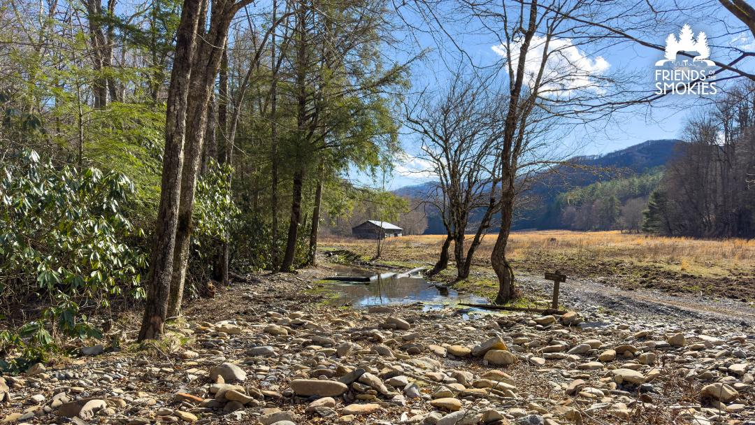 Damage to Cataloochee Road with the Caldwell Barn in the background in Great Smoky Mountains National Park. Repairs following Tropical Storm Helene continue and will be supported by a grant from the Colquitt Foundation. Friends of the Smokies
$750K donation to Friends of the Smokies part of a larger $2 million commitment to assist Hurricane Helene recovery
Jim Matheny is Friends of the Smokies communications director.
KODAK — Reflecting a longtime devotion to Great Smoky Mountains National Park, The Colquitt Foundation has given $750,000 to the nonprofit Friends of the Smokies to save historic structures and help the national park’s Cataloochee Valley recover from damage caused by Hurricane Helene.
“Hurricane Helene left its mark on Cataloochee Valley. Cataloochee Ranch was founded in that valley, and we feel a responsibility to help. We are honored to partner with Friends of the Smokies to contribute towards its revival and restoration,” David Colquitt said.
The Colquitt Foundation made the gift on behalf of The Swag as well as Cataloochee Ranch, two historic mountain retreats operated by the Colquitts on the boundary of Great Smoky Mountains National Park in Haywood County, North Carolina.
“Cataloochee Valley is a jewel for our entire region. Its cultural, historical, environmental and recreational value is something that cannot be replaced. On behalf of our 150+ Haywood County team members, we are honored to make this contribution,” Annie Colquitt said.
The $750,000 gift to Friends of the Smokies will fund restoration of historic structures damaged by Hurricane Helene in September 2024, including cabins and barns from Cataloochee to Cosby. Through the Forever Places program, these critically needed funds will provide materials, supplies and support for a skilled staff of historic preservation experts to make the needed repairs.
- hurricane helene
- hurricane helene cataloochee
- hurricane helene smokies
- hurricane economic loss
- hurricane helene western north carolina
- colquitt foundation
- the swag
- david colquitt
- caldwell barn cataloochee
- helene repairs in smokies
- dana soehn
- friends of great smoky mountains national park
- friends of the smokies
- beech grove school
- cataloochee ranch