
Earth (254)
Planet Earth, the only speck in the Universe confirmed by humans to have evolved higher forms of life. Watch NASA's phenomenal movie summarizing Life on Earth.
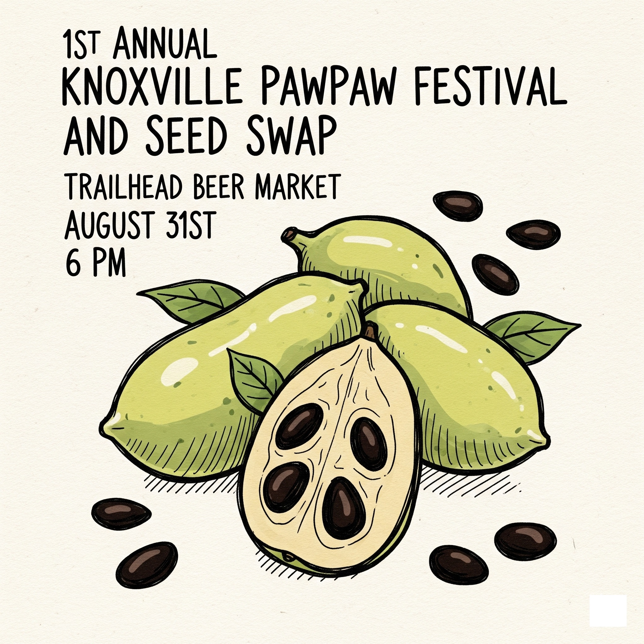
Swap seeds and stories and sample local pawpaws at first Pawpaw Festival
KNOXVILLE — Multiple wildcrafters, seed collectors and general treehuggers — and wild critters — here and throughout the Southern Appalachians are really getting into wild pawpaw trees and their fruit.
Asimina triloba, the American papaw, is native to hardwood forest understories of the eastern United States, including the rich oak, hickory and maple forests of the Appalachians. It can be cultivated on private land or urban food plots, and of course grows richly in area forests. Its fruit is widely described as custard-like in texture.
There is a growing critical mass of pawpaw fans to meet occasionally and swap seed and its Knoxville’s turn to recognize the humble yet mighty local fruit. The first of what is planned to be an annual event is set 6 p.m. Aug. 31 at the Trailhead Beer Market, 1317 Island Home Ave.
Feds award expedited work on Newfound Gap Road after latest regional weather disaster
Written by Katie Liming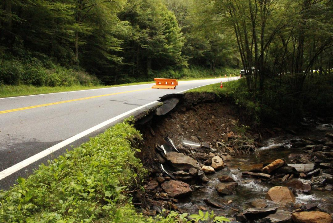 Newfound Gap Road through Great Smoky Mountains National Park remains closed because of a washout between Sugarlands and Newfound Gap that occurred during a heavy rain event; park officials anticipate it reopening by Sept. 30. Kenzie Connor via NPS
US 441 from Sugarlands to Newfound Gap expected to reopen by end of September after heavy rains wash out roadway
Katie Liming is a public information officer with the National Park Service.
GATLINBURG — The National Park Service and the Federal Highway Administration continue to work quickly to repair the road washout on US 441/Newfound Gap Road. The FHWA has awarded the contract to Eclipse Companies, LLC, and the NPS and FHWA held a pre-construction meeting with the contractor on Friday. The contractor was expected to begin mobilizing equipment and supplies this week.
Construction is expected to be completed on or before September 30.
The park responded Aug. 1 to reports of a road washout and landslide event on Newfound Gap Road between mile marker 12 and 13 on the Tennessee side of the park (south of Alum Cave trailhead).
The affected area spans about 125 feet and has significantly undercut nearly the entire width of the southbound lane. On August 2, NPS and FWHA engineers visited the slide and immediately began project scoping. Both agencies worked quickly to complete the required steps of the design, permitting and contracting processes for construction.
- us 441/newfound gap road
- smokies heavy rain
- us 441 closed
- can i drive through smokies
- sugarlands
- great smoky mountains national park
- great smoky mountains national park climate change
- smokies storm damage
- smokies travel conditions
- smokies news
- shuttle services in great smoky mountains national park
- smokies shuttle
Helene: Colquitt Foundation gives $750,000 for ongoing recovery in Smokies
Written by Jim Matheny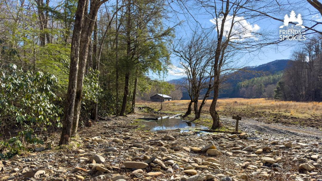 Damage to Cataloochee Road with the Caldwell Barn in the background in Great Smoky Mountains National Park. Repairs following Tropical Storm Helene continue and will be supported by a grant from the Colquitt Foundation. Friends of the Smokies
$750K donation to Friends of the Smokies part of a larger $2 million commitment to assist Hurricane Helene recovery
Jim Matheny is Friends of the Smokies communications director.
KODAK — Reflecting a longtime devotion to Great Smoky Mountains National Park, The Colquitt Foundation has given $750,000 to the nonprofit Friends of the Smokies to save historic structures and help the national park’s Cataloochee Valley recover from damage caused by Hurricane Helene.
“Hurricane Helene left its mark on Cataloochee Valley. Cataloochee Ranch was founded in that valley, and we feel a responsibility to help. We are honored to partner with Friends of the Smokies to contribute towards its revival and restoration,” David Colquitt said.
The Colquitt Foundation made the gift on behalf of The Swag as well as Cataloochee Ranch, two historic mountain retreats operated by the Colquitts on the boundary of Great Smoky Mountains National Park in Haywood County, North Carolina.
“Cataloochee Valley is a jewel for our entire region. Its cultural, historical, environmental and recreational value is something that cannot be replaced. On behalf of our 150+ Haywood County team members, we are honored to make this contribution,” Annie Colquitt said.
The $750,000 gift to Friends of the Smokies will fund restoration of historic structures damaged by Hurricane Helene in September 2024, including cabins and barns from Cataloochee to Cosby. Through the Forever Places program, these critically needed funds will provide materials, supplies and support for a skilled staff of historic preservation experts to make the needed repairs.
- hurricane helene
- hurricane helene cataloochee
- hurricane helene smokies
- hurricane economic loss
- hurricane helene western north carolina
- colquitt foundation
- the swag
- david colquitt
- caldwell barn cataloochee
- helene repairs in smokies
- dana soehn
- friends of great smoky mountains national park
- friends of the smokies
- beech grove school
- cataloochee ranch
Incredible Farm Dinner Downtown

Last year’s Annual Incredible Farm Dinner Downtown had to be cancelled because of Hurricane Helene.
The already legendary Greeneville tradition celebrates local farms and community. It’s hosted by the Rural Resources Farm & Food Education Center. Many local sponsors, businesses, farms, churches and the Town of Greeneville make this event possible. Get your tickets early! The dinner sells out every year, a testament to its success and the value of the Rural Resources programming it supports.
Maryville honors East Tennessee conservation giant with fields and forests
Written by Allison Lester A public park planned along U.S. 321 in Maryville will honor East Tennessee conservation legend Billy Minser. Linda Albert via social media
The park will host hiking trails and natural areas for the public to enjoy
MARYVILLE — The city and Foothills Land Conservancy (FLC) have partnered on the creation of Billy Minser Park, a new 23-acre public green space set to open in 2025 off U.S. 321 in Blount County.
The property for the park was donated by the late Catherine Gilreath to FLC and the City of Maryville with the shared goal of creating a space for public enjoyment and environmental education. The park is under a conservation easement — meaning it will be protected from development forever.
When complete, Billy Minser Park will feature hiking and walking trails along a scenic creek corridor through forests and open fields. It will serve as a place for the community to connect with nature while preserving local habitat.
The park honors William “Billy” Minser — a beloved conservationist, educator and long-time FLC board member whose career has spanned decades in forestry, wildlife management and land preservation.
Land donation protects Obed-area wildlands on eastern fringes of Cumberland Plateau
Written by Ben Pounds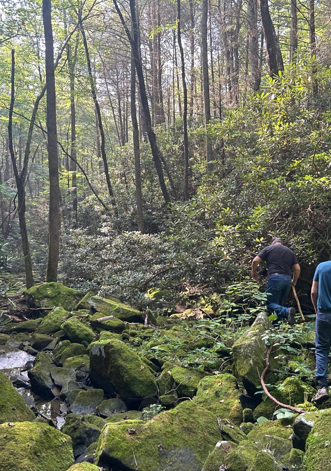 Hikers walk along Ramsey Creek during a dry time. Tennessee Citizens for Wilderness Planning has assembled land to be turned over to the National Park Service to expand public lands at the Obed Wild and Scenic River. Chuck Estes/Tennessee Citizens for Wilderness Planning
There’s more room to roam in the Cumberlands thanks to Oak Ridge-based citizens group
WARTBURG — As East Tennesseans and tourists alike enjoy summer fun on the wild Obed River, enthusiasts are growing its amount of federally protected land.
Part of the U.S. National Park Service system, the Obed Wild and Scenic River in Cumberland and Morgan Counties on Tennessee’s Cumberland Plateau offers swimming, hiking, picnicking, kayaking, fishing and climbing at the federally protected park. It currently includes about 45 miles along streams like the Obed and Emory Rivers.
Residents of Oak Ridge, a little less than an hour’s drive away, created Tennessee Citizens for Wilderness Planning (TCWP) and lobbied to create the federally protected area in 1976. Now, the same group, through fundraising and land swaps with anonymous private individuals, has gained 30 acres on which it plans to build a trail connected to the federal land.
- obed national wild and scenic river
- tennessee citizens for wilderness planning
- tennessee land preservation
- cumberland mountain quail
- cumberland plateau
- cumberland hiking
- new hiking trails in east tennessee
- hiking in tennessee
- recreation
- fishing
- kayaking
- climbing
- ramsey creek
- national park service
- hellbender
- citizen action
A happy ending and new beginning after a sad story at Appalachian Bear Rescue
Written by Hellbender Press Rosemary Bear (class of 2022) cools off in a cub tub (all to herself this time, thank you) on a hot July day at Appalachian Bear Rescue in Townsend. The center entered a new agreement with licensing authority Tennessee Wildlife Resources Agency that calls for improved sanitation, regular pen rotation and burnovers and other management techniques. TWRA euthanized 13 bears in December 2024 following fatal and persistent strains of pneumonia. The center has been closed since; ABR director Greg Grieco said on July 22 the facility expects to complete renovations and be ready for the next crop of orphaned and injured bears by spring 2026. Appalachian Bear Rescue
TWRA and bear rescue center reach agreement to resume rehab services at Townsend facility next year
This is a joint release from the Tennessee Wildlife Resources Agency and Appalachian Bear Rescue.
NASHVILLE — The Tennessee Wildlife Resources Agency (TWRA) and Appalachian Bear Rescue (ABR) have reached a new partnership agreement for black bear rehabilitation in Tennessee.
During the course of 2023 and 2024, the presence of pneumonia raised initial concerns about the health of bears being housed at ABR. After a difficult decision in December 2024 to euthanize 13 bears, the agency temporarily paused the placement of bears at the facility.
In the months that followed, TWRA staff sought input from bear managers, wildlife veterinarians and disease pathologists in other states on best management practices and pen sanitation measures such as discing, burns and leaving pens empty on an annual rotational schedule. ABR staff immediately started working to implement extensive modifications and upgrades to the facility to align with the recommendations of these professionals.
TWRA leadership also began working with ABR to draft an official operating agreement to strengthen the relationship between the two entities, set clear expectations for best management practices for bear rehabilitation and provide transparency to members of the public invested in wildlife conservation.
Hellbender Press receives three first-place awards for Helene reporting
Written by Thomas FraserTeam coverage of Sept. 27 disaster spanned three devastated East Tennessee watersheds
KNOXVILLE — Hellbender Press continued its tradition of excellence in journalism in 2024 with award-winning coverage of the unprecedented disaster spawned by Tropical Storm Helene in the Southern Appalachians.
Editor and Publisher Thomas Fraser and writer and reporter John Stambaugh accepted the awards at an East Tennessee Society of Professional Journalists downtown banquet in May.
The society sponsors the competition each year to recognize the best journalism in East Tennessee published in 2024. This year’s contest was judged by the Oklahoma Society of Professional Journalists.
Hellbender Press received three first-place awards in the digital-only category, all related to Helene: Hurricane Helene Breaking Coverage; Deadline/Breaking News Reporting; and Series/Package/Project Writing.
Two of the judges drew parallels with news coverage of other historic events.
Bees, fish and plants show how climate change is disrupting nature in 2 key ways
Written by Courtney McGinnis A bee pollinates an almond tree in an orchard. Concerns are growing that there is an increasing disconnect between pollinating plants and their pollinators due to climate change. David Kosling/U.S. Department of Agriculture
The problem with climate change isn’t just the temperature. It’s how fast the climate is changing.
This story was originally published by The Conversation. Courtney McGinnis is a professor of biology, medical sciences and environmental sciences at Quinnipiac University.
Historically, Earth’s climate changes have generally happened over thousands to millions of years. Today, global temperatures are increasing by about 0.36 degrees Fahrenheit (0.2 degrees Celsius) per decade.
Imagine a car speeding up. Over time, human activities such as burning fossil fuels, have increased the amount of greenhouse gases in the atmosphere. These gases trap heat from the Sun. This is like pressing the gas pedal. The faster the driver adds gas, the faster the car goes.
The 21st century has seen a dramatic acceleration in the rate of climate change, with global temperatures rising more than three times faster than in the previous century.
The faster pace and higher temperatures are changing habitat ranges for plants and animals. In some regions, the pace of change is also throwing off the delicate timing of pollination, putting plants and pollinators such as bees at risk.
Some species are already migrating
Most plant and animal species can tolerate or at least recover from short-term changes in climate, such as a heat wave. When the changes last longer, however, organisms may need to migrate into new areas to adapt for survival.
- climate change
- global warming
- climate change effects
- courtney mcginnis
- quinnipiac university
- climate change migration
- bees climate change
- fish climate change
- species diversity
- species extinction
- the conversation
- greenhouse gases
- plants and pollinators
- plants and climate change
- diapause
- phenological mismatch
- early blooming climate change
TN General Assembly slashes state wetlands protections
Written by Cassandra Stephenson Water collects among trees at the West Tennessee Wetlands Mitigation Bank — a wetland restored from its days as farmland — near the Loosahatchie River in Shelby County, Tenn. Karen Pulfer Focht for Tennessee Lookout
Bill’s supporters call it a win for private property; opponents say it’s a loss for all Tennesseans
This story was originally published by Tennessee Lookout.
NASHVILLE — A bill slashing regulations for an estimated 80 percent of Tennessee’s non-federally protected wetlands headed to Gov. Bill Lee’s desk this week after receiving approval from the General Assembly.
The bill’s West Tennessee Republican sponsors — Rep. Kevin Vaughan and Sen. Brent Taylor — said the legislation removes onerous and seemingly subjective mitigation requirements for landowners and developers.
Environmental advocates and scientists said the legislation paves the way for the destruction of Tennessee’s natural resources.
The bill passed 71-21 with one abstention in the House, and 25-6 in the Senate.
Since the 1970s, wetland regulations in Tennessee have required developers and landowners to seek permission from the state before draining or altering wetlands. The swampy areas can host diverse species, soak up rain water and filter it as it seeps into groundwater tables, recharging aquifers. Alterations to wetlands required developers to pay for mitigation — efforts to preserve or restore other wetlands nearby.
- tennessee wetlands bill
- state wetland protections
- tn development lobby
- loosahatchie river
- shelby county wetlands
- cassandra stephenson
- wetland mitigation bank
- wetland protection rollback in tennessee
- wetland regulation
- wetland conservation
- wetland restoration
- wetland alteration
- isolated wetland
- southern environmental law center
- wetland mitigation
- blue oval city
- tennessee department of environment and conservation
- wetland benefit
- tennessee wildlife federation
- supreme court isolated wetland ruling
Happy Earth Day to you! Happy Earth Day to YOU.
Written by EarthSolidarity!™
What can YOU, and those around you, do to make your lifestyle more sustainable?
Today is a good opportunity to make a resolution or a promise to yourself and those around you to adopt a new habit or practice that will reduce your environmental impacts. Perhaps, you have already taken such a step a while ago and you may now scale it up or add something else to it?
EarthSolidarity!™ is focusing on individual and small-group initiatives that facilitate practical, local, down-to-Earth actions that can readily be replicated by many and thus add up to significant improvements in the community, the bioregion and — through equivalent locally and regionally tuned initiatives — contribute to our national and even global environmental health.
You may have found that it’s not so difficult, and perhaps you discovered some ways of making it easier or more successful than you thought possible at first. If so, please This email address is being protected from spambots. You need JavaScript enabled to view it..
Encourage those next to you to adopt the same or similar action. We are looking for leaders like you that are willing to help organize or just advise small environmental action groups at the neighborhood level or within local businesses and organizations.
University of Tennessee leads the way in this year’s local Earth Day observances
KNOXVILLE — It’s once again time to celebrate Earth Day — Earth Week, really — and as it has in past years, Hellbender Press has a few suggestions for some fun ways for families to celebrate the planet we call home on April 22 and beyond.
The theme of this year’s Earth Day, which is its 55th observance, is Our Power, Our Planet.
If you have items you’d like to add to the list, please email This email address is being protected from spambots. You need JavaScript enabled to view it..
This list will be updated.
STEAM Earth Day event
— 6-7 p.m., Tuesday, April 22, Carter Branch Library, 9036 Asheville Highway, Knoxville. Register here.
The University of Tennessee Office of Sustainability Earth Week
— The sustainability office has an entire month devoted to Earth Day.
— 3 p.m.-5 p.m., Tuesday April 22, UT Gardens, 2514 Jacob Drive: Join a cleanup of Third Creek.
— 11 a.m.-2 p.m. April 22, 21st Mortgage Plaza, UT Earth Day Festival will feature fun games, food and drinks.
Babies and Blooms Earth Day Festival
— 10 a.m.-1 p.m. Saturday, April 26, INCubator, 100 Cherokee Blvd., Chattanooga
Updated 4/18: Smoky gray: Former Smokies leader warns of more funding cuts; popular campsites remain closed; still little information on cuts at Great Smoky Mountains National Park
Written by Elan Young, Ben Pounds and Thomas Fraser Campers are seen enjoying a morning at Elkmont Campground in Great Smoky Mountains National Park. Elkmont is one of the Smokies campgrounds still open. National Park Service
National parks advocate and former Smokies official warns of funding shortfalls as closures continue, concerns persist, and people resist
KNOXVILLE — Funding for national parks has never amounted to much, and the federal government will cut even more if people don’t speak out in defense of the country’s natural and ecological crown jewels.
That was the message from Phil Francis, chairman of the Coalition to Protect American National Parks and former acting superintendent of Great Smoky Mountains National Park. He spoke to an audience at Knoxville’s Schulz Bräu Brewing Company hosted by Discover Life in America. Francis said that due to rising concerns his organization grew from 500 members to over 4,000 during the Trump administration. The coalition, he said, includes many people like himself who used to work for the park system, including the former superintendent of Acadia National Park.
Francis advocated that others should lobby government officials to continue to support the parks.
“If you don’t speak up, it makes it a lot more difficult,” he told the audience.
- elan young
- smokies job cuts
- federal job cuts
- rangers
- smokies rangers fired
- how many lost jobs at smokies
- smokies parking fees
- great smoky mountains economic impact
- national parks conservation association
- association of national park rangers
- hellbender press reporting on job cuts
- probationary workers fired
- great smoky mountains national park
- big south fork national river and recreation area
- maintenance backlog
- jeff hunter
- bill wade
- cades cove loop road
- carfree experience in cades cove
- carfree wednesdays in cades cove
- garry shores
- townsend
- townsend protest
- gatlinburg protest
- phil francis
- discover life in america
- ben pounds
- national park funding
- trump national park cuts
Wetlands protections built an industry. Rollbacks could erode it.
Written by Cassandra Stephenson and Delany Dryfoos Paul Stoddard, a principal at environmental consulting firm EnSafe, unlocks the gate to the West Tennessee Wetlands Mitigation Bank in Shelby County. EnSafe planted more than 50,000 trees to restore portions of this 250-acre wetland, creating credits for developers to purchase to offset destruction of wetlands elsewhere. Karen Pulfer Focht for Tennessee Lookout
Interests of all stripes push to preserve state wetlands protections against pro-developer pressure
This story is part of the series Down the Drain from the Mississippi River Basin Ag & Water Desk, an independent reporting collaborative based at the University of Missouri in partnership with Report for America, with major funding from the Walton Family Foundation.
LEWISBURG — Fourth-generation Middle Tennessee cattle farmer Cole Liggett lined up with scientists and environmental advocates in March to urge Tennessee lawmakers not to gut the state’s historically strong protections for wetlands.
Wetlands protection has been good business for Liggett. In addition to raising cattle, he’s a manager at Headwaters Reserve, a firm that developers pay to preserve and restore wetlands and streams so they can destroy them elsewhere, called mitigation banking. If lawmakers follow through on a plan to deregulate an estimated 80 percent of the state’s isolated wetlands, that will upend the industry in Tennessee and drive up prices for developers still required to pay for mitigation, Liggett testified.
Liggett works in a growing industry that operates more than 2,500 mitigation banks nationwide, earning an estimated $3.5 billion in revenue in 2019, according to a 2023 study funded by the Ecological Restoration Business Association.
The industry is built on demand spurred by the 1972 U.S. Clean Water Act, which requires developers to offset their damage to wetlands by building or restoring wetlands nearby.
But recent federal actions to shrink the scope of that law are pushing states to choose how strictly they will regulate wetlands. The consequences of those decisions not only threaten further degradation of land, water and wildlife, but also the fortunes of an industry that has made a big business out of conservation.
Have a cold one with former Smokies official at this month’s Conservation on Tap
Written by Hellbender Press
KNOXVILLE — Discover Life in America has a newly established partnership with Schulz Bräu Brewing Company to host its monthly Conservation on Tap speaker series.
The latest installment of the series at the new venue is 7 p.m. April 16. Join Conservation on Tap at Schulz Bräu Brewing Company, 126 Bernard Ave, Knoxville.
Join us for an insightful presentation by Phil Francis, Chairman of the Coalition to Protect America’s National Parks, and former acting superintendent of GSMNP, as he provides an update on the current challenges facing the National Park Service and our national parks.
Francis will discuss the critical resources that need protection and the staffing necessary to ensure the preservation and maintenance of these cherished public lands. This event is a must-attend for anyone passionate about the future of America’s national parks and the efforts needed to safeguard them for generations to come. Learn more at: protectnps.org.
Come support local conservation efforts and enjoy a wide selection of 20+ beers on-tap (and plenty of nonalcoholic beverages) and some authentic German fare from Schulzes Schnitzel Kitchen.
- discover life in america
- schulzbrau
- knoxville environmental events
- nature lectures knoxville
- kimberly smith
- wilderness society
- safe passage i40 pigeon river gorge wildlife corridor
- wildlife corridor
- smokies cuts
- phil francis
- conservation on tap
- federal science cuts
- great smoky mountains national park
UT joins forces with two state agencies to promote healthy forests and their wildlife in Tennessee
Written by Katie Donaldson One of the goals behind a recent partnership among UTIA and state agencies is the promotion of heartier food species such as this oak. The new five-year agreement between the UTIA Tree Improvement Program, the Tennessee Division of Forestry and the Tennessee Wildlife Resources Agency focuses on developing locally adapted and genetically improved seed for future Tennessee forests. Allison Mains/UTIA
UTIA Tree Improvement Program and state agencies work together to protect and conserve the state’s forest resources
Katie Donaldson is a communications specialist for the University of Tennessee School of Natural Resources.
KNOXVILLE — A new, five-year agreement establishes how the state of Tennessee and a program in the University of Tennessee Institute of Agriculture will study and produce tree seedlings to promote the protection and conservation of Tennessee forests.
The UTIA Tree Improvement Program (UT-TIP), the Tennessee Department of Agriculture Division of Forestry (TDF) and the Tennessee Wildlife Resources Agency (TWRA) partnered on the agreement.
“Honoring our land-grant mission, we are excited about this partnership to responsibly research, develop, manage and conserve forest resources across the great state of Tennessee,” said Keith Carver, UTIA senior vice chancellor and senior vice president.
UT-TIP manages numerous seed orchards in East, Middle and West Tennessee with help from state and federal partners. It uses the orchards to provide the East Tennessee Nursery with locally adapted and genetically improved seed.
More...
Helene: A battered Cataloochee reopens six months after hurricane
Written by Kendra Straub Upper Cataloochee Road was among the many infrastructure victims in Great Smoky Mountains National Park following Hurricane Helene. Cataloochee Valley was the hardest-hit section of the park. The park service said it intends to reopen the road April 4. National Park Service
Cataloochee to mostly reopen in Great Smoky Mountains National Park; campground will remain closed following Smokies cuts; many downed trees and washouts still affecting multiple area trails
Kendra Straub is a communications officer with the National Park Service.
CATALOOCHEE — The National Park Service (NPS) will reopen portions of Cataloochee Valley in Great Smoky Mountains National Park beginning April 4. Cataloochee Valley has been closed since September 2024 following significant damage from Hurricane Helene. Within the park, Cataloochee Valley saw the worst impacts from Hurricane Helene.
The following roads will open to vehicles in Cataloochee on April 4: Cataloochee Entrance Road up to Beech Grove School; Cataloochee Creek Road to the Old Cataloochee Entrance Road Bridge; and Old Highway 284. Visitors will be able to drive Cataloochee Valley Entrance Road up to Beech Grove School.
First UT sustainability symposium offers a collaborative vision for the future
Written by Lucas Hunter
All great scientific solutions start with collaboration
KNOXVILLE — The challenges facing the planet and its inhabitants have long been too complex for any one individual or group to address, and that’s why the great advancements in modern science begin with conferences, symposiums and collaboration.
The first Environmental Future Symposium is an effort from the University of Tennessee Office of Sustainability to present a vision of the future for area residents and University of Tennessee students.
Planned for the Agriculture and Natural Resources Ballroom and Plaza from 2 p.m. to 6 p.m. March 27, the symposium is spearheaded by the office’s Alternative Energy and Transportation Coordinator Ben Gouffon. His vision for the event is simple: at the intersection of human-accelerated climate destabilization and a revitalization of the collapsing biosphere sits every individual and their actions. His hope is that this symposium is an avenue for every attendee to discover what they can do for Knoxville, the university and the planet they call home.
 Cameroon’s vast and species-rich rainforests are of great importance for global biodiversity and the climate. They are also an important source of food and income for local people. A new study on hunting patterns in the jungles of West Africa includes research gathered by a University of Tennessee professor. Thomas Imo/German Federal Government
Adam Willcox subsisted on bush meat during African hunting study
Katie Donaldson is a communications specialist for the University of Tennessee School of Natural Resources.
KNOXVILLE — Data collected by a University of Tennessee research associate nearly 30 years ago is part of an extensive study that focuses on hunting patterns in African tropical forests.
Adam Willcox, a research associate professor in the UT Institute of Agriculture School of Natural Resources, co-authored the article, which was published recently in Nature Sustainability. “Regional patterns of wild animal hunting in African tropical forests” was also written by Daniel J. Ingram, research fellow at the University of Kent, and several other researchers. The data show how hunting management is needed to sustain wild animal populations in West and Central Africa.
The article uses data collected from 1991 to 2022 in 83 different studies to create a regional analysis of hunting patterns. Willcox contributed to the publication using research and data he gathered from 1996 to 2001 while promoting agroforestry in the U.S. Peace Corps in Cameroon. “I was in a lowland tropical forest. We did not have domestic alternatives for protein. We had to eat wild animals,” Willcox said. “My research followed 100 hunters around a wildlife sanctuary in Cameroon and their harvests.”
- university of tennessee professor ate research subjects
- adam willcox
- ut institute of agriculture
- human hunting patterns
- bush meat
- hunting management
- ut ag research
- nature sustainability
- wild animal populations in west and central africa
- biodiversity
- subsistence hunting
- agroforestry
- university of kent
Helene: Haul water, rescue pigs, help neighbors: How Warren Wilson College students confronted climate chaos
Written by Mallory McDuff A student farm leader takes care of pigs at Warren Wilson College in Swannanoa. Most of the college’s pigs were recovered following fatal flooding from the Swannanoa River on Sept. 28, 2024. Warren Wilson College
Collective action helps alleviate climate anxiety in wake of Hurricane Helene
This story was originally published by The Revelator.
Mallory McDuff teaches environmental education at Warren Wilson College.
SWANNANOA, N.C. — “We need 10 people on flush crew, five to clean out the fridges in the science building, and 15 to clear trees on the roads! We’re gonna do this together!”
This wasn’t a pep rally or a community service event. It was the morning meeting called at 9:30 a.m. each day by campus leaders in front of the cafeteria at the small college where I lived without power or water, after the climate disaster of Hurricane Helene devastated our community in Western North Carolina.
“We know the Swannanoa Valley has been hit especially hard,” the college president told the group of students and employees. “And we are here for this college and for the greater community. This is our work together.”
That day I joined my neighbor Tom Lam chain-sawing his way across campus with a crew of students clearing brush along the way.
“Now gather ‘round so you can see how to sharpen this chainsaw,” Tom said in his booming Jersey voice, pulling on his suspenders after we’d cleared trees that crushed a neighbor’s car.
I’ve spent 25 years teaching environmental education, raising two daughters, and living at this 1,000-acre campus where all students work in jobs in places like the farm, garden, forests, and even fiber arts. And I think this might be one model of how to live in community in a climate emergency.
- how to live in community in a climate emergency
- warren wilson college
- hurricane helene warren wilson
- hurricane helene
- hurricane helene local impacts
- swannanoa
- swannanoa river
- mallory mcduff
- hurricane helene livestock
- climate emergency
- climate activist
- was warren wilson hit by hurricane
- what did warren wilson do during hurricane
- extreme weather
- southern appalachians natural disaster